Latitude: 51.5811 / 51°34'51"N
Longitude: -2.0965 / 2°5'47"W
OS Eastings: 393411
OS Northings: 186918
OS Grid: ST934869
Mapcode National: GBR 2QZ.YK1
Mapcode Global: VH95S.MJ19
Plus Code: 9C3VHWJ3+CC
Entry Name: 87-93, High Street
Listing Date: 6 August 1974
Last Amended: 19 July 1996
Grade: II
Source: Historic England
Source ID: 1269361
English Heritage Legacy ID: 460857
ID on this website: 101269361
Location: Burton Hill, Wiltshire, SN16
County: Wiltshire
Civil Parish: Malmesbury
Built-Up Area: Malmesbury
Traditional County: Wiltshire
Lieutenancy Area (Ceremonial County): Wiltshire
Church of England Parish: Malmesbury and Brokenborough
Church of England Diocese: Bristol
Tagged with: Building
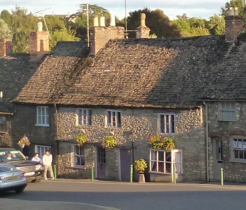
MALMESBURY
ST9386 HIGH STREET
758-1/3/194 (South side)
06/08/74 Nos.87-93 (Odd)
(Formerly Listed as:
HIGH STREET
(South side)
Nos.87-103, 107, 113-13 (Odd))
GV II
Terrace of 4 houses. Late C17/early C18, extended early C19.
Limestone rubble with brick ridge and gable stacks and stone
slate roof. Double-depth plan.
2 storeys; 1:2:1-window range. The terrace of 3 houses slopes
down hill to the left, and No.89 is attached to the rear of
No.87. Timber lintels extend across ground-floor openings to
Nos 91 and 93; No.93 has an 8-pane former shop window, No.91
has a central C20 half-glazed door with a 2/2-pane sash to the
left and a boarded door to through-passage to the right. No.87
has an entrance in the square-framed side passage, and an
early C19 canted ground-floor bay with large panes; original
3-light mullion windows with central leaded metal casements,
No.91 with stays and fittings. No.89 is a 2-window range with
C19 casements and timber lintels, with a plank door.
INTERIOR: not inspected.
Listing NGR: ST9341186918
External links are from the relevant listing authority and, where applicable, Wikidata. Wikidata IDs may be related buildings as well as this specific building. If you want to add or update a link, you will need to do so by editing the Wikidata entry.


Other nearby listed buildings