Approximate Location Map
Large Map »
Latitude: 51.5824 / 51°34'56"N
Longitude: -2.0973 / 2°5'50"W
OS Eastings: 393353
OS Northings: 187065
OS Grid: ST933870
Mapcode National: GBR 2QZ.QKB
Mapcode Global: VH95S.LHL8
Plus Code: 9C3VHWJ3+X3
Entry Name: 42, High Street
Listing Date: 1 July 1976
Grade: II
Source: Historic England
Source ID: 1269409
English Heritage Legacy ID: 460821
ID on this website: 101269409
Location: Malmesbury, Wiltshire, SN16
County: Wiltshire
Civil Parish: Malmesbury
Built-Up Area: Malmesbury
Traditional County: Wiltshire
Lieutenancy Area (Ceremonial County): Wiltshire
Church of England Parish: Malmesbury and Brokenborough
Church of England Diocese: Bristol
Tagged with: Building
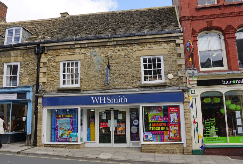
MALMESBURY
ST9387 HIGH STREET
758-1/4/157 (East side)
01/07/76 No.42
GV II
House, then pair of shops, now in one occupation. Late C18
with late C19 and C20 shop fronts. Limestone rubble and
dressings with a truncated brick stack and stone slate roof.
PLAN: U-shaped with single-depth front and rear wings to a
through-passage.
EXTERIOR: 2 storeys and attic; 2:2-window range. Former No.40,
half the width of No.42, has a full-width shop front has thin
mullions to plate-glass windows, consoles to a fascia, with
recessed right-hand doorway with a good C18 fanlight and
4-panel door, and recessed shop window between the windows;
rendered lintels to 2/2-pane first-floor sashes in exposed
boxes, and cambered heads to 2 casement dormers. No.42 to the
right has a full-width shop front, quoins above and a plain
fascia, with widely-spaced windows with rendered lintels to
8/8-pane sashes in exposed sashes. Good cast-iron hopper with
lion head, decorative downpipe and full-width gutter with an
ivy leaf pattern.
INTERIOR: details include a winder stair over the
through-passage, and a first-floor front room with a dividing
elliptical arch.
Listing NGR: ST9335987068
External links are from the relevant listing authority and, where applicable, Wikidata. Wikidata IDs may be related buildings as well as this specific building. If you want to add or update a link, you will need to do so by editing the Wikidata entry.


Other nearby listed buildings
