Approximate Location Map
Large Map »
Latitude: 51.5823 / 51°34'56"N
Longitude: -2.0976 / 2°5'51"W
OS Eastings: 393330
OS Northings: 187049
OS Grid: ST933870
Mapcode National: GBR 2QZ.QH6
Mapcode Global: VH95S.LHFD
Plus Code: 9C3VHWJ2+WW
Entry Name: 43 and 43A, High Street
Listing Date: 1 July 1976
Grade: II
Source: Historic England
Source ID: 1269410
English Heritage Legacy ID: 460822
ID on this website: 101269410
Location: Malmesbury, Wiltshire, SN16
County: Wiltshire
Civil Parish: Malmesbury
Built-Up Area: Malmesbury
Traditional County: Wiltshire
Lieutenancy Area (Ceremonial County): Wiltshire
Church of England Parish: Malmesbury and Brokenborough
Church of England Diocese: Bristol
Tagged with: Building
MALMESBURY
ST9387 HIGH STREET
758-1/4/158 (West side)
01/07/76 Nos.43 AND 43A
GV II
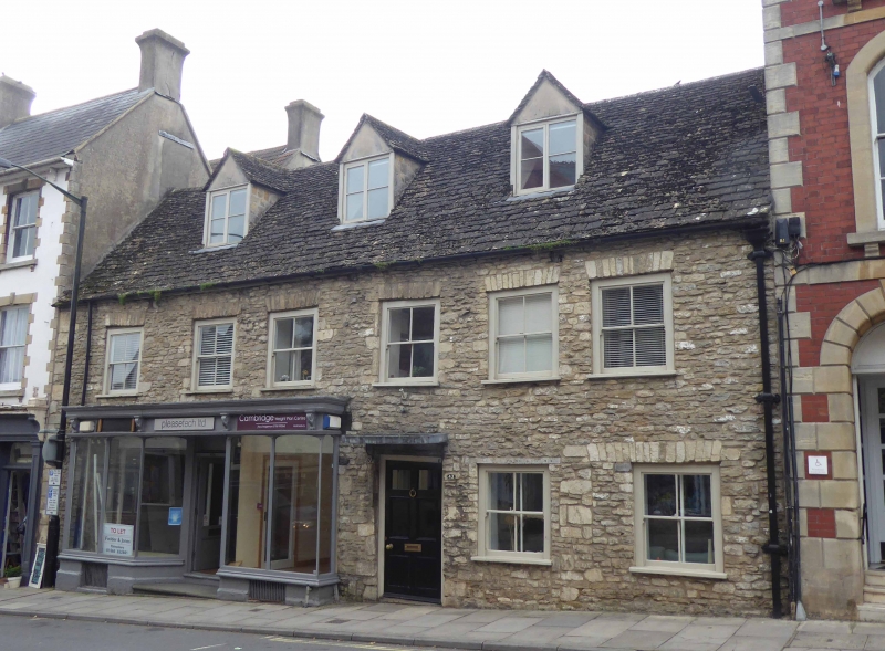
Pair of houses, now one house and shop. Late C18. Limestone
rubble with brick right-hand party wall stack and stone slate
roof.
PLAN: double-depth plan with a central through-passage and
rear left-hand range.
EXTERIOR: 2 storeys and attic; 6-window range. A regular front
has unevenly-spaced windows and rough quoins, a
right-of-centre 6-panel doorway, the top pair glazed, and late
C19 projecting shop front with thin mullions and a console
cornice with a central recessed doorway. Roughly-dressed stone
flat arches to 2/2-pane horned exposed sashes, that to the
right of the doorway has a timber lintel; the head of the
right-hand ground-floor window extends to the left above a
straight joint with rough jamb stones. 3 gabled casement
dormers.
Rear elevation has 3 gables, tallest to the N, smallest
central gable with mullion leaded casements, the S gable
projects with a mid C19 lower range attached, with mullion
first-floor windows.
INTERIOR: not inspected but reported as having chamfered
ceiling beams.
Listing NGR: ST9331987049
External links are from the relevant listing authority and, where applicable, Wikidata. Wikidata IDs may be related buildings as well as this specific building. If you want to add or update a link, you will need to do so by editing the Wikidata entry.


Other nearby listed buildings
