Latitude: 51.5839 / 51°35'1"N
Longitude: -2.0984 / 2°5'54"W
OS Eastings: 393278
OS Northings: 187226
OS Grid: ST932872
Mapcode National: GBR 2QZ.Q94
Mapcode Global: VH95S.LG05
Plus Code: 9C3VHWM2+GJ
Entry Name: Numbers 3 and 5 and Attached Wall
Listing Date: 1 July 1976
Last Amended: 19 July 1996
Grade: II*
Source: Historic England
Source ID: 1269449
English Heritage Legacy ID: 460777
ID on this website: 101269449
Location: Malmesbury, Wiltshire, SN16
County: Wiltshire
Civil Parish: Malmesbury
Built-Up Area: Malmesbury
Traditional County: Wiltshire
Lieutenancy Area (Ceremonial County): Wiltshire
Church of England Parish: Malmesbury and Brokenborough
Church of England Diocese: Bristol
Tagged with: Building
MALMESBURY
ST9387 GLOUCESTER STREET 758-1/4/114 (North side) 01/07/76 Nos.3 AND 5 and attached wall (Formerly Listed as: MARKET CROSS (West side) No.4) (Formerly Listed as: GLOUCESTER STREET (North side) Nos.3 AND 5)
GV II*
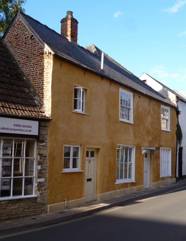
Pair of houses, incorporating part of former wall from Church of St Paul's. C15 church wall, C17 house, refronted and extended to left early C19. Limestone rubble and dressings to rear gable, timber framed house with a rendered brick front, C17 central stack behind the ridge, and C19 party wall stack and slate roof hipped to the right and a rear gable. PLAN: 2-room plan with central stack and matching small left-hand extension; C17 rear wall incorporates part of C15 church. EXTERIOR: 2 storey 3-window range. A symmetrical front has a 6-panel door, the top pair glazed and formerly with a bracketed hood, C19 shop windows each side with 8 panes, and 8/8-pane sashes in exposed frames above; to the left a 1-window C19 range with right-hand half-glazed door, 6-pane recessed ground-floor window and second-floor top-hung casement. Rear gable wall formerly part of C15 S wall of chancel and nave, including 2 blocked 3-centre arches, with tracery visible inside. INTERIOR: includes C15 work from St Paul's Church; first-floor has a Tudor-arched fireplace with moulded, stopped surround, cornice above and flanked by arched salt niches, and an oak framed doorway between first-floor rooms with chamfered reveals and scroll bracketed head, once flanked by crudely-carved cherubs now in town museum. Adjacent door re-using section of C15 muntin and plank partition. Downstairs rear window overlies a moulded 4-centre arched stone doorway. SUBSIDIARY FEATURES: approx 5m of attached rubble wall extends W of NW corner; it includes a large blocked opening (former window) with quoining and timber lintel over low doorway. HISTORICAL NOTE: See St Paul's Bell Tower (qv).
(Wiltshire Buildings Record: Trowbridge, WLBR B 145).
Listing NGR: ST9328387229
External links are from the relevant listing authority and, where applicable, Wikidata. Wikidata IDs may be related buildings as well as this specific building. If you want to add or update a link, you will need to do so by editing the Wikidata entry.


Other nearby listed buildings