Latitude: 54.195 / 54°11'41"N
Longitude: -2.8873 / 2°53'14"W
OS Eastings: 342208
OS Northings: 478052
OS Grid: SD422780
Mapcode National: GBR 8M8X.QZ
Mapcode Global: WH83D.MTBF
Plus Code: 9C6V54V7+X3
Entry Name: Garden Temple at Holme Island House to South of House Including Attached Bridge
Listing Date: 2 May 1975
Grade: II
Source: Historic England
Source ID: 1269653
English Heritage Legacy ID: 460546
ID on this website: 101269653
Location: Westmorland and Furness, Cumbria, LA11
County: Westmorland and Furness
District: South Lakeland
Civil Parish: Grange-over-Sands
Traditional County: Lancashire
Lieutenancy Area (Ceremonial County): Cumbria
Church of England Parish: Grange-over-Sands St Paul
Church of England Diocese: Carlisle
Tagged with: Temple
GRANGE-OVER-SANDS
SD47NW MEATHOP ROAD, Holme Island 705-1/2/51 (East side (off)) 02/05/75 Garden Temple at Holme Island House, to S of house, including attached bridge
II
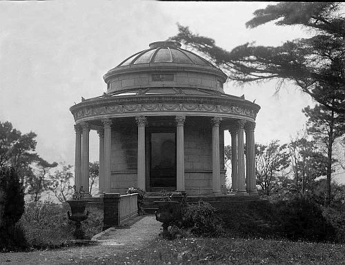
Garden temple. Probably mid C19. Limestone ashlar with cast-iron columns and lead-covered dome. Circular plan, surrounded by a moat spanned on the north side by a cast-iron bridge with limestone abutments and 'turned' iron balustrades. The temple is raised on 3 limestone steps and has 16 Corinthian columns supporting a circular entablature decorated with goats' heads and swags. The central drum has low windows on 4 sides and is capped by a dome. On the north side there are curved panelled double doors set in an architrave with a cornice on brackets. 3 round-headed niches face in the other cardinal directions. INTERIOR: not fully inspected. Appears to have 2 enriched cornices, a dome with mural painting, niches with leaf decoration to their spandrels, and a central rectangular block of stone. Holme Island House not included.
Listing NGR: SD4220878052
External links are from the relevant listing authority and, where applicable, Wikidata. Wikidata IDs may be related buildings as well as this specific building. If you want to add or update a link, you will need to do so by editing the Wikidata entry.


Other nearby listed buildings