Approximate Location Map
Large Map »
Latitude: 54.1734 / 54°10'24"N
Longitude: -2.9257 / 2°55'32"W
OS Eastings: 339670
OS Northings: 475682
OS Grid: SD396756
Mapcode National: GBR 8N05.DQ
Mapcode Global: WH83L.1C3G
Plus Code: 9C6V53FF+8P
Entry Name: Kents Bank House
Listing Date: 2 May 1975
Grade: II
Source: Historic England
Source ID: 1269673
English Heritage Legacy ID: 460522
ID on this website: 101269673
Location: Kents Bank, Westmorland and Furness, Cumbria, LA11
County: Cumbria
District: South Lakeland
Civil Parish: Grange-over-Sands
Built-Up Area: Grange-over-Sands
Traditional County: Lancashire
Lieutenancy Area (Ceremonial County): Cumbria
Church of England Parish: Allithwaite St Mary
Church of England Diocese: Carlisle
Tagged with: House
GRANGE-OVER-SANDS
SD3975 KIRKHEAD ROAD, Kents Bank
705-1/5/55 (North side)
02/05/75 Kent's Bank House
GV II
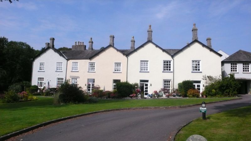
House, used as inn and school during C19 and now Christian
holiday centre. Early and mid C19 with later C19 additions.
Roughcast with slate roof.
EXTERIOR: the south 2-window range, adjoining Mews Cottage
(qv), appears to be the earliest part and is of 2 storeys plus
attic. On the ground floor there are timber canted bay windows
which have casements with glazing bars. The upper floors have
glazing bar sashes in narrow painted surrounds with projecting
sills. The attic windows are partly within gabled dormers. In
the centre is a blocked doorway with round-arched head now
containing a window. Chimneys to left and right. To the right
a gable wall projects forwards and is blank except for a wide
early C20 timber canted bay window on the ground floor. The
verges project on brackets and there is a chimney, with
limestone cap, at the apex. The east 2-window range has 2
similar gables. The windows are glazing bar sashes. Ground
floor largely covered by a mid C20 flat-roofed extension which
projects forwards and has casements with glazing bars. Two
further gables to the right are in a style similar to the main
building, but appear to be later additions. The right-hand one
has French doors on the ground floor. Below the left-hand
gable are 2 bays, with French doors on the ground floor in the
right-hand bay.
INTERIOR: not fully inspected, but said to contain no features
of architectural interest.
HISTORY: on the 1st edition of the Six Inch Ordnance Survey
map, surveyed in the late 1840s, the building is marked as the
Kents Bank Inn.
Listing NGR: SD3967075682
External links are from the relevant listing authority and, where applicable, Wikidata. Wikidata IDs may be related buildings as well as this specific building. If you want to add or update a link, you will need to do so by editing the Wikidata entry.


Other nearby listed buildings
