Approximate Location Map
Large Map »
Latitude: 53.3675 / 53°22'3"N
Longitude: -1.5022 / 1°30'7"W
OS Eastings: 433219
OS Northings: 385741
OS Grid: SK332857
Mapcode National: GBR 98Q.DN
Mapcode Global: WHCCJ.WMT8
Plus Code: 9C5W9F9X+24
Entry Name: Hunters Bar Toll Gate
Listing Date: 12 December 1995
Grade: II
Source: Historic England
Source ID: 1270820
English Heritage Legacy ID: 457182
ID on this website: 101270820
Location: Sharrow Vale, Sheffield, South Yorkshire, S11
County: Sheffield
Electoral Ward/Division: Ecclesall
Parish: Non Civil Parish
Built-Up Area: Sheffield
Traditional County: Yorkshire
Lieutenancy Area (Ceremonial County): South Yorkshire
Church of England Parish: Endcliffe St Augustine
Church of England Diocese: Sheffield
Tagged with: Architectural structure
SHEFFIELD
SK3385NW ECCLESALL ROAD
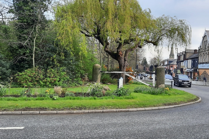
784-1/35/279 Hunters Bar toll gate
II
Toll gate. c1810, resited early C20. 2 tapered round ashlar
piers with rounded tops. Renewed single bar gate. Ecclesall
Road was laid out as a toll road in 1810.
Listing NGR: SK3321985741
External links are from the relevant listing authority and, where applicable, Wikidata. Wikidata IDs may be related buildings as well as this specific building. If you want to add or update a link, you will need to do so by editing the Wikidata entry.


Other nearby listed buildings
