Approximate Location Map
Large Map »
Latitude: 52.9506 / 52°57'2"N
Longitude: -1.1548 / 1°9'17"W
OS Eastings: 456886
OS Northings: 339576
OS Grid: SK568395
Mapcode National: GBR LNQ.3F
Mapcode Global: WHDGZ.73CC
Plus Code: 9C4WXR2W+63
Entry Name: Garden Buildings and Adjoining Boundary Wall at Castle Museum
Listing Date: 30 November 1995
Grade: II
Source: Historic England
Source ID: 1271107
English Heritage Legacy ID: 455785
ID on this website: 101271107
Location: Standard Hill, Nottingham, Nottinghamshire, NG1
County: City of Nottingham
Electoral Ward/Division: Radford and Park
Parish: Non Civil Parish
Built-Up Area: Nottingham
Traditional County: Nottinghamshire
Lieutenancy Area (Ceremonial County): Nottinghamshire
Church of England Parish: Nottingham St Peter with St James
Church of England Diocese: Southwell and Nottingham
Tagged with: Building
NOTTINGHAM
SK5639NE CASTLE ROAD
646-1/19/122 (West side (off))
Garden buildings and adjoining
boundary wall at Castle Museum
GV II
Garden buildings and adjoining boundary wall. Early C19 with
additions c1877-78 and mid C20. Coursed squared stone and
brick, with ashlar dressings and hipped slate roof with
rendered ridge stack.
Single storey; 3 window range. 2 large casements, 2 and 3
lights, with wooden mullions. To left, a C19 4-panel door and
beyond, a large board door. Right return has a porch with
wooden Ionic columns and pediment, moulded 6-panel door and
fanlight. Beyond, to left, flat roofed and lean-to additions,
C19 and C20. To right, a similar addition.
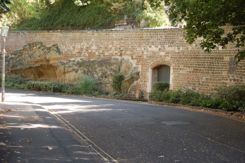
The rear of the building forms part of the boundary wall to
the castle grounds. This runs from the north gateway to the
garden buildings, approx 3m high and 40m long, with slab
coping. Beyond the garden building, a similar stretch approx
20m long, ending with an ashlar pier. Beyond this, a section
approx. 2m high and 60m long, with a segment-arched doorway.
The boundary wall was probably built during alterations to
improve access to the Park in 1809 and 1821, with further
alterations by TC Hine in 1877-78. The wall is partly built on
a natural rock outcrop.
(Get to know Nottingham: Brand K: The Park Estate, Nottingham:
Nottingham: 1984-: 9).
Listing NGR: SK5688639575
External links are from the relevant listing authority and, where applicable, Wikidata. Wikidata IDs may be related buildings as well as this specific building. If you want to add or update a link, you will need to do so by editing the Wikidata entry.


Other nearby listed buildings
