Approximate Location Map
Large Map »
Latitude: 51.8603 / 51°51'36"N
Longitude: -2.2587 / 2°15'31"W
OS Eastings: 382281
OS Northings: 217997
OS Grid: SO822179
Mapcode National: GBR 0JT.CRS
Mapcode Global: VH94B.SHSR
Plus Code: 9C3VVP6R+4G
Entry Name: Llanthony Priory, Remains of Precinct Wall South of Outer Gatehouse
Listing Date: 23 January 1952
Last Amended: 15 December 1998
Grade: I
Source: Historic England
Source ID: 1271696
English Heritage Legacy ID: 472290
ID on this website: 101271696
Location: High Orchard, Gloucester, Gloucestershire, GL2
County: Gloucestershire
District: Gloucester
Electoral Ward/Division: Westgate
Parish: Non Civil Parish
Built-Up Area: Gloucester
Traditional County: Gloucestershire
Lieutenancy Area (Ceremonial County): Gloucestershire
Church of England Parish: Hempsted with Gloucester, Saint Mary de Lode and Saint Mary de Crypt
Church of England Diocese: Gloucester
Tagged with: Wall
GLOUCESTER
SO81NW LLANTHONY ROAD
844-1/3/159 (East side)
23/01/52 Llanthony Priory, Remains of
Precinct Wall south of Outer
Gatehouse
(Formerly Listed as:
HEMPSTED LANE
Remains of Llanthony Priory)
GV I
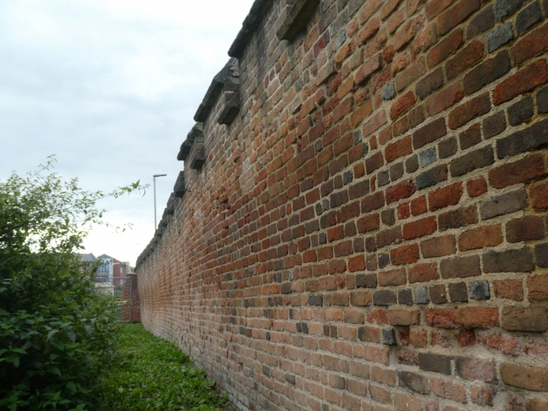
Precinct wall of Llanthony Priory to the south of the Remains
of Outer Gatehouse (qv) on the west side of the outer court.
Early C16. Red brick in English bond with patterns in
vitrified headers.
EXTERIOR: crenellated wall from which the original weathered
coping stones have been robbed; about 1m below modern ground
level the base of the wall is built above the revetment to the
former outer moat; on the outer face, approx 18m south of the
gatehouse, three decorative patterns in vitrified brick, the
right-hand pattern in the form of a wayside cross, lozenge
patterns on left side and chequer patterns to middle.
The wall is a very early known example of brickwork in
Gloucestershire, and in a regional context of a type more
common in the south-east of England.
Listing NGR: SO8228117998
External links are from the relevant listing authority and, where applicable, Wikidata. Wikidata IDs may be related buildings as well as this specific building. If you want to add or update a link, you will need to do so by editing the Wikidata entry.


Other nearby listed buildings
