Approximate Location Map
Large Map »
Latitude: 51.5383 / 51°32'17"N
Longitude: -0.14 / 0°8'23"W
OS Eastings: 529097
OS Northings: 183796
OS Grid: TQ290837
Mapcode National: GBR D2.RQ
Mapcode Global: VHGQS.JLCL
Plus Code: 9C3XGVQ6+82
Entry Name: Former Chapel to St Martin in the Fields Almshouses
Listing Date: 14 May 1974
Grade: II
Source: Historic England
Source ID: 1272269
English Heritage Legacy ID: 476639
ID on this website: 101272269
Location: Camden Town, Camden, London, NW1
County: London
District: Camden
Electoral Ward/Division: Camden Town with Primrose Hill
Parish: Non Civil Parish
Built-Up Area: Camden
Traditional County: Middlesex
Lieutenancy Area (Ceremonial County): Greater London
Church of England Parish: St Pancras Old Church
Church of England Diocese: London
Tagged with: Chapel
CAMDEN
TQ2983NW BAYHAM STREET
798-1/77/61 (East side)
14/05/74 Former chapel to St Martin-in-the
Fields Almshouses
GV II
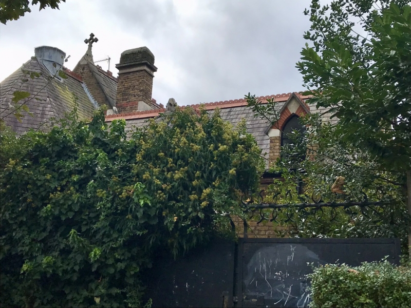
Former chapel to St Martin-in-the-Fields Almshouses (qv),
situated centrally at rear of houses. 1880-81. By H Jacques.
For the Parish of St Martin-in-the-Fields. Yellow stock brick
with red brick and stone dressings; slated hipped roof with
decorative red ridge tiles.
Single storey with 3 bays and hexagonal sanctuary with
projecting side chapel on north side. Gothic style with
lancets having trefoil heads.
INTERIOR: converted into house with floored-over gallery. Red
and white striped banding on pointed chancel arch and above 3
pointed windows at east end. Open timber roof. Some encaustic
floor tiles at east end.
HISTORICAL NOTE: Jacques was responsible for a scheme of
improvements to the almshouses in 1880-1 that also included an
infirmary and matron's residence.
The former chapel forms a group with St Martin-in-the-Fields
Almshouses (qv).
(Survey of London: Vol. XXIV, King's Cross Neighbourhood, St
Pancras part IV: London: -1952: 136).
Listing NGR: TQ2909783796
External links are from the relevant listing authority and, where applicable, Wikidata. Wikidata IDs may be related buildings as well as this specific building. If you want to add or update a link, you will need to do so by editing the Wikidata entry.


Other nearby listed buildings
