Approximate Location Map
Large Map »
Latitude: 51.3831 / 51°22'59"N
Longitude: 0.2152 / 0°12'54"E
OS Eastings: 554249
OS Northings: 167224
OS Grid: TQ542672
Mapcode National: GBR TS.QXT
Mapcode Global: VHHP6.PH4K
Plus Code: 9F3296M8+63
Entry Name: 40, London Road
Listing Date: 22 October 1982
Grade: II
Source: Historic England
Source ID: 1274294
English Heritage Legacy ID: 415683
ID on this website: 101274294
Location: Farningham, Sevenoaks, Kent, DA4
County: Kent
District: Sevenoaks
Civil Parish: Farningham
Built-Up Area: Eynsford
Traditional County: Kent
Lieutenancy Area (Ceremonial County): Kent
Church of England Parish: Farningham St Peter and St Paul
Church of England Diocese: Rochester
Tagged with: Building
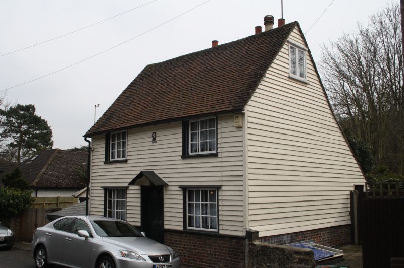
FARNINGHAM LONDON ROAD
1.
5280
No 40
TQ 5467 9/134
II GV
2.
C18. Two storeys faced with weatherboarding on a brick base. Tiled roof.
Two horizontally-sliding sash windows. Wooden pedimented doorcase. Six panelled
door.
Listing NGR: TQ5425167221
External links are from the relevant listing authority and, where applicable, Wikidata. Wikidata IDs may be related buildings as well as this specific building. If you want to add or update a link, you will need to do so by editing the Wikidata entry.


Other nearby listed buildings
