Approximate Location Map
Large Map »
Latitude: 51.3678 / 51°22'4"N
Longitude: 0.2114 / 0°12'40"E
OS Eastings: 554032
OS Northings: 165513
OS Grid: TQ540655
Mapcode National: GBR TT.PXN
Mapcode Global: VHHP6.MW3B
Plus Code: 9F329696+4G
Entry Name: Ford House and Eynsford Post Office
Listing Date: 22 October 1982
Grade: II
Source: Historic England
Source ID: 1275536
English Heritage Legacy ID: 411961
ID on this website: 101275536
Location: Eynsford, Sevenoaks, Kent, DA4
County: Kent
District: Sevenoaks
Civil Parish: Eynsford
Built-Up Area: Eynsford
Traditional County: Kent
Lieutenancy Area (Ceremonial County): Kent
Church of England Parish: Eynsford St Martin
Church of England Diocese: Rochester
Tagged with: Post office
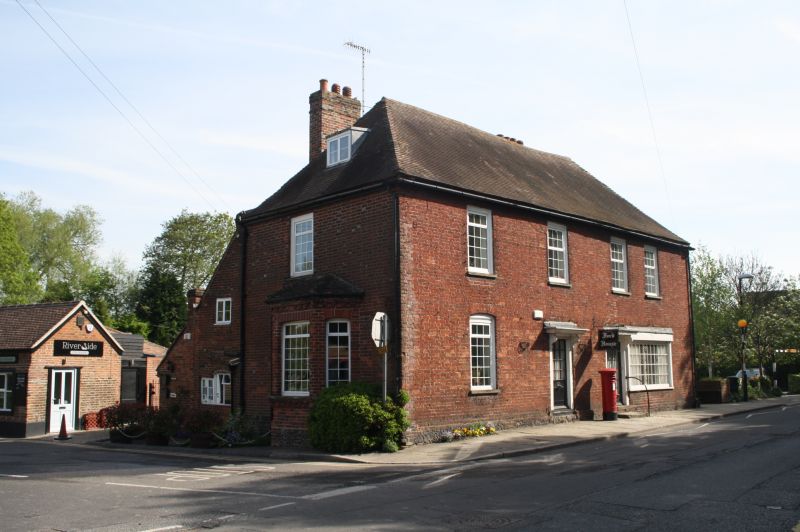
EYNSFORD HIGH STREET
1.
5280 (north-west side)
Ford House and
Eynsford Post Office
TQ 5465 12/51
II GV
2.
C18. Two storeys red brick. Hipped tiled roof. Four sashes with glazing bars
intact. Two doorcases with projecting cornices on brackets and shopfront with
reeded architraves.
Listing NGR: TQ5403165514
External links are from the relevant listing authority and, where applicable, Wikidata. Wikidata IDs may be related buildings as well as this specific building. If you want to add or update a link, you will need to do so by editing the Wikidata entry.


Other nearby listed buildings
