Approximate Location Map
Large Map »
Latitude: 51.3765 / 51°22'35"N
Longitude: 0.1598 / 0°9'35"E
OS Eastings: 550413
OS Northings: 166372
OS Grid: TQ504663
Mapcode National: GBR S4.2XV
Mapcode Global: VHHP5.QNBN
Plus Code: 9F3295G5+HW
Entry Name: Manor Cottage
Listing Date: 22 October 1982
Grade: II
Source: Historic England
Source ID: 1275552
English Heritage Legacy ID: 411938
ID on this website: 101275552
Location: Crockenhill, Sevenoaks, Kent, BR8
County: Kent
District: Sevenoaks
Civil Parish: Crockenhill
Built-Up Area: Crockenhill
Traditional County: Kent
Lieutenancy Area (Ceremonial County): Kent
Church of England Parish: Crockenhill All Souls
Church of England Diocese: Rochester
Tagged with: Cottage
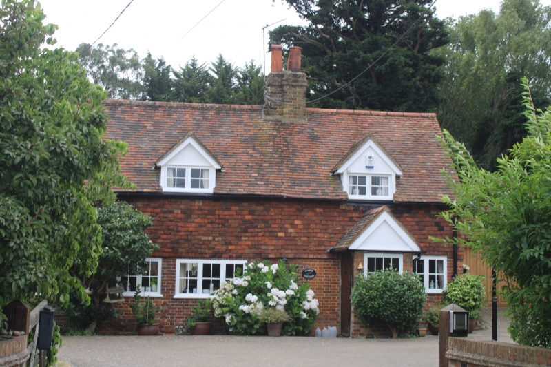
TQ 56 NW CROCKENHILL DALTONS ROAD
994/2/37 Number 31
(Manor Cottage)
II
C18. Two storeys. Ground floor red brick with grey headers on flint plinth. First floor tile hung. Tiled roof. Three gabled dormers. Four casement windows. Later gabled weather porch.
Listing NGR: TQ5306164557
External links are from the relevant listing authority and, where applicable, Wikidata. Wikidata IDs may be related buildings as well as this specific building. If you want to add or update a link, you will need to do so by editing the Wikidata entry.


Other nearby listed buildings
