Approximate Location Map
Large Map »
Latitude: 50.8525 / 50°51'9"N
Longitude: -1.1737 / 1°10'25"W
OS Eastings: 458258
OS Northings: 106214
OS Grid: SU582062
Mapcode National: GBR 9B2.J2N
Mapcode Global: FRA 86FV.8JY
Plus Code: 9C2WVR3G+2G
Entry Name: 3, Union Street
Listing Date: 22 October 1976
Grade: II
Source: Historic England
Source ID: 1276654
English Heritage Legacy ID: 408786
ID on this website: 101276654
Location: Fareham, Hampshire, PO16
County: Hampshire
District: Fareham
Electoral Ward/Division: Fareham East
Parish: Non Civil Parish
Built-Up Area: Fareham
Traditional County: Hampshire
Lieutenancy Area (Ceremonial County): Hampshire
Church of England Parish: Fareham St Peter and St Paul
Church of England Diocese: Portsmouth
Tagged with: Building
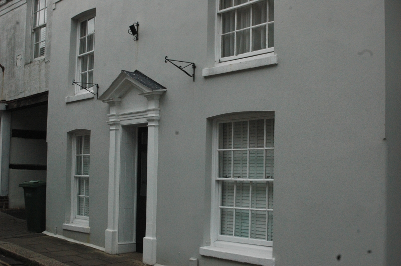
UNION STREET
1.
5231 (East Side)
Fareham
No 3
SU 5806 SW 1/48
II GV
2.
C18. Stuccoed with parapet and tiled roof. 2 storeys. 3 windows, sashes with
glazing bars. Doorway with pilasters and pediment.
All the listed buildings in Union Street form a group with the listed buildings
in High Street.
Listing NGR: SU5825706213
External links are from the relevant listing authority and, where applicable, Wikidata. Wikidata IDs may be related buildings as well as this specific building. If you want to add or update a link, you will need to do so by editing the Wikidata entry.


Other nearby listed buildings
