Latitude: 53.3445 / 53°20'40"N
Longitude: -2.052 / 2°3'7"W
OS Eastings: 396636
OS Northings: 383070
OS Grid: SJ966830
Mapcode National: GBR GY3R.KS
Mapcode Global: WHBBB.G63C
Plus Code: 9C5V8WVX+R6
Entry Name: The Cage
Listing Date: 14 April 1967
Grade: II*
Source: Historic England
Source ID: 1277283
English Heritage Legacy ID: 407227
ID on this website: 101277283
Location: Cheshire East, Cheshire, SK12
County: Cheshire East
Civil Parish: Lyme Handley
Traditional County: Cheshire
Lieutenancy Area (Ceremonial County): Cheshire
Church of England Parish: Disley St Mary
Church of England Diocese: Chester
Tagged with: Tower
SJ 98 SE LYME HANDLEY C.P. LYME PARK
4/73 The Cage.
14/4/1967 II*
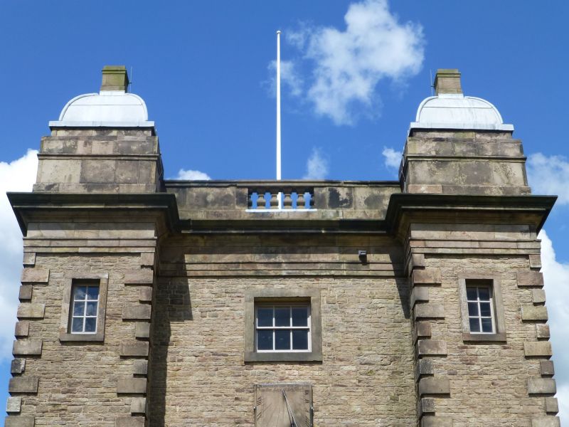
Formerly hunting tower cum gatehouse, later park keeper's house and prisoners' lock-up: Origins c.1580, taken down 1734 by George Platt, rebuilt 1737 by Peter Platt, perhaps to a design by Leoni for Peter Legh X. Coursed, squared, buff sandstone rubble with ashlar sandstone dressings, felted roof and cupolas (originally stone) and formerly 2 chimneys. In plan, square with attached square corner towers. 3-storeys symmetrical fronts. Chamfered plinth, raised rusticated quoins, applied ashlar band at first floor. Windows in towers in raised, plain surrounds (now blocked but with 12-pane sashes originally). Semi-circular headed doorcases on 3 faces, with rusticated surrounds and Tuscan pilaster capitals to imposts with raised plain, window surrounds above (all blocked). Projecting heavily-moulded entablature with ashlar blocking course with central balustrading (probably added by Wyatt, now damaged). On towers, stepped bases to domed cupolas (now C20 wooden replacements) 3 square sundials on moulded sills between 1st and 2nd storeys, read: east face, "Vive Hodie"; south face, "Remember now the creator in the days of thy youth"; west face, "Cras minus aptus eris". Interior: 4 Tuscan antae with banded rustication in ground floor. Diagonal flight leads to spiral, stone staircase in south-west corner tower. Remainder of interior now removed but first floor was the main room with a panelled oak ceiling with huge, central, carved rosette. The stairs were in one corner, a fireplace, a lavatory, and a prison room in the others.
All the elements used in the rebuild can be found in the south and west ranges of Lyme Park (q.v.) but it is not certain if the C16 structure (paralled by an example at Chatsworth) was totally demolished or not.
Listing NGR: SJ9663683070
External links are from the relevant listing authority and, where applicable, Wikidata. Wikidata IDs may be related buildings as well as this specific building. If you want to add or update a link, you will need to do so by editing the Wikidata entry.


Other nearby listed buildings