Latitude: 53.1073 / 53°6'26"N
Longitude: -1.5617 / 1°33'42"W
OS Eastings: 429437
OS Northings: 356765
OS Grid: SK294567
Mapcode National: GBR 599.7YM
Mapcode Global: WHCDV.Z5H7
Plus Code: 9C5W4C4Q+W8
Entry Name: Unnumbered Premises Between 45 Cromford Hill and the Arkwright Houses
Listing Date: 12 September 1990
Last Amended: 27 April 1992
Grade: II
Source: Historic England
Source ID: 1277691
English Heritage Legacy ID: 430741
ID on this website: 101277691
Location: Cromford, Derbyshire Dales, Derbyshire, DE4
County: Derbyshire
District: Derbyshire Dales
Civil Parish: Cromford
Built-Up Area: Cromford
Traditional County: Derbyshire
Lieutenancy Area (Ceremonial County): Derbyshire
Church of England Parish: Cromford St Mary
Church of England Diocese: Derby
Tagged with: Architectural structure
In the entry for: 1. NORTH STREET 1390 CROMFORD
SK 2856/2956 Unnumbered houses to 1/135 the north side between No 1 North Street and No 45 Cromford Hill GV II
The address and the description shall be amended to read:
1. 1390 NORTH STREET CROMFORD
SK2856/2956 Unnumbered premises 1/135 between 45 Cromford Hill and The Arkwright Houses
GV II
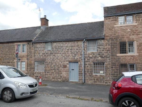
Former workshop now school of homeopathy. Mid C18, altered (appears to predate The Arkwright Houses of 1776-7. (q.v.). Coursed sandstone rubble; tile roof. 2 storeys, 2 windows to 1st floor. Former doorway to far left now with stonework below 24-pane casement; boarded door near centre and 20-pane casement on right. All have large stone lintels, 1st floor: a small 9-pane casement and a 16-pane sash. chamfered eaves band. Brick stack to left on party wall with 45 Cromford Hill (q.v.). Rear: external steps. The premises form an annexe to the unnumbered house at left end of The Arkwright Houses.
NB Part of this item now forms 45 Cromford Hill and is listed separately under item 1/110A
------------------------------------
NORTH STREET 1. 1390 CROMFORD Unnumbered houses to the north side between No. 1 North street and No. 45 Cromford Hill SK 2856/2956 1/135
II GV
2. Two houses. Possibly C18 (marked in outline but not numbered on Tithe Map of 1841). The bonding between the right-hand house and No. 1 North Street suggests that the former pre-dates the latter (qv). Coursed rubble; tiled roofs under two levels. 2 brick ridge stacks. 2 storeys. The left-hand house once served as an inn and may originally have been a 3-room plan farmhouse, and the other formerly a barn (or warehouse: see ventilators to rear). 3-window range with blocked doorway between the two left window bays. 2 sash and one casement windows to first floor; one horned sash and 2 C20 casement windows to ground. Blocked doorway with massive lintel and jamb blocks. The other house a 2-window range; all windows in early openings, C20 frames with glazing bars. Rear with external steps and ventilator openings; otherwise windows renewed.
Listing NGR: SK2943756764
External links are from the relevant listing authority and, where applicable, Wikidata. Wikidata IDs may be related buildings as well as this specific building. If you want to add or update a link, you will need to do so by editing the Wikidata entry.


Other nearby listed buildings