Latitude: 53.2175 / 53°13'3"N
Longitude: -2.9179 / 2°55'4"W
OS Eastings: 338805
OS Northings: 369336
OS Grid: SJ388693
Mapcode National: GBR 78.1CQJ
Mapcode Global: WH887.4DS6
Plus Code: 9C5V639J+2R
Entry Name: Mollington Grange
Listing Date: 1 June 1967
Last Amended: 27 November 1984
Grade: II
Source: Historic England
Source ID: 1278768
English Heritage Legacy ID: 404823
ID on this website: 101278768
Location: Cheshire West and Chester, Cheshire, CH1
County: Cheshire West and Chester
Civil Parish: Mollington
Traditional County: Cheshire
Lieutenancy Area (Ceremonial County): Cheshire
Church of England Parish: Upton The Holy Ascension
Church of England Diocese: Chester
Tagged with: Building
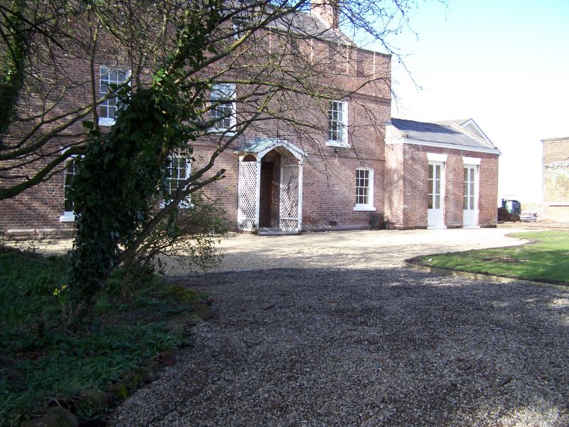
SJ 36 NE MOLLINGTON C.P. PARKGATE ROAD
(East Side)
4/35 Mollington Grange
(formerly listed as
Little Mollington Hall).
1/6/1967
- II
Farmhouse: C16/C17 origins but rebuilt late C17/early C18 with later
C18 and mid C19 alterations. English bond orange brick on red
sandstone plinth, Welsh slate roof, 1 ridge and 2 gable brick
chimneys. Much altered plan of parlour, hall and service rooms.
2½-storey, 4-bay south front. Brick band at 1st and 2nd floor and
stone-coped parapet with recessed square panels, 2 pierced to light
attic windows. 12-pane sashes with segmental brick heads and 1
16-pane with flat stone head, replace a symmetrical facade of many now
blocked windows. Moulded'wooden doorcase with panelled soffits behind
flimsy wooden porch has door with 4 fielded panels and plain fanlight.
1-storey, 2-bay C19 extension to the right.
Interior: 2 staircases, 1 dogleg with square newels and a heavy
handrail and no balusters and added parallel rail. The other is late
C18 open string with plain balusters and mahogany handrail, except for
upper flight with square newels and good twisted balusters of c1700.
Some heavy cased ceiling beams and evidence of wattle and daub and a
now hidden intramural stone stair. 6-panelled doors in moulded
architraves.
The dairy and cheese rooms added to the north-east are not included in
the item.
Listing NGR: SJ3880569336
External links are from the relevant listing authority and, where applicable, Wikidata. Wikidata IDs may be related buildings as well as this specific building. If you want to add or update a link, you will need to do so by editing the Wikidata entry.


Other nearby listed buildings