Latitude: 51.4985 / 51°29'54"N
Longitude: -0.1561 / 0°9'22"W
OS Eastings: 528086
OS Northings: 179342
OS Grid: TQ280793
Mapcode National: GBR 9K.30
Mapcode Global: VHGQZ.7LTL
Plus Code: 9C3XFRXV+CG
Entry Name: 3, Halkin Place SW1
Listing Date: 1 December 1987
Grade: II
Source: Historic England
Source ID: 1279353
English Heritage Legacy ID: 210006
ID on this website: 101279353
Location: Belgravia, Westminster, London, SW1X
County: London
District: City of Westminster
Electoral Ward/Division: Knightsbridge and Belgravia
Parish: Non Civil Parish
Built-Up Area: City of Westminster
Traditional County: Middlesex
Lieutenancy Area (Ceremonial County): Greater London
Church of England Parish: St Paul Knightsbridge
Church of England Diocese: London
Tagged with: Building
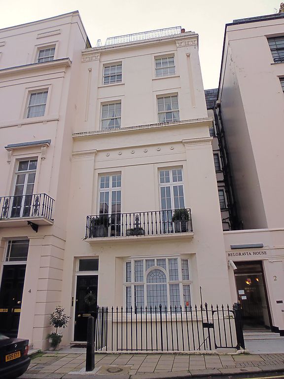
TQ 2879 SW CITY OF WESTMINSTER HALKIN PLACE
97/16 SW1 (west side)
14.1.70 No 3
GV II
House. Early C19, altered. Stucco. Slate mansard. 4 storeys, mansard attic
and basement. 2 windows wide. Ground floor altered c1900, with entrance to
left. First floor cast iron balcony. Giant pilasters rising through ground and
first floors. Cornice above first floor; pilasters united second and third
floors. Windows square headed, sashes, French casements to first floor, some
glazing bars. Cornice above fourth floor. One of a pair with No 1.
Listing NGR: TQ2808679342
External links are from the relevant listing authority and, where applicable, Wikidata. Wikidata IDs may be related buildings as well as this specific building. If you want to add or update a link, you will need to do so by editing the Wikidata entry.


Other nearby listed buildings