Latitude: 51.4984 / 51°29'54"N
Longitude: -0.1559 / 0°9'21"W
OS Eastings: 528106
OS Northings: 179331
OS Grid: TQ281793
Mapcode National: GBR 9K.51
Mapcode Global: VHGQZ.7LYP
Plus Code: 9C3XFRXV+9M
Entry Name: The Star Tavern
Listing Date: 1 December 1987
Grade: II
Source: Historic England
Source ID: 1357183
English Heritage Legacy ID: 208634
Also known as: Star Tavern, Belgravia
The Star Tavern, Belgravia
ID on this website: 101357183
Location: Belgravia, Westminster, London, SW1X
County: London
District: City of Westminster
Electoral Ward/Division: Knightsbridge and Belgravia
Parish: Non Civil Parish
Built-Up Area: City of Westminster
Traditional County: Middlesex
Lieutenancy Area (Ceremonial County): Greater London
Church of England Parish: St Paul Knightsbridge
Church of England Diocese: London
Tagged with: Pub
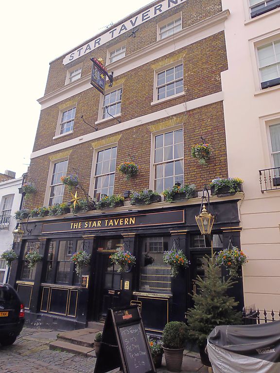
TQ 2879 SW CITY OF WESTMINSTER BELGRAVE MEWS WEST SW1
97/58 (west side)
No 6 (The Star Tavern)
GV
II
Public house. Early to mid C19. 3 storeys, plus attic, 3 windows wide.
Brick. Stucco to ground floor. Pilastered sub-front. Square headed window with
gauged heads. Sashes, glazing bars. Cornice above second floor. Words "Star
Tavern" in stucco to attic. Interior not inspected. Included for group value only.
Listing NGR: TQ2810679331
External links are from the relevant listing authority and, where applicable, Wikidata. Wikidata IDs may be related buildings as well as this specific building. If you want to add or update a link, you will need to do so by editing the Wikidata entry.


Other nearby listed buildings