Latitude: 54.9022 / 54°54'8"N
Longitude: -1.418 / 1°25'4"W
OS Eastings: 437417
OS Northings: 556546
OS Grid: NZ374565
Mapcode National: GBR V69.09
Mapcode Global: WHD5C.610P
Plus Code: 9C6WWH2J+VQ
Entry Name: North Chapel Bishopwearmouth Cemetery
Listing Date: 17 October 1994
Grade: II
Source: Historic England
Source ID: 1279542
English Heritage Legacy ID: 391405
ID on this website: 101279542
Location: Bishopwearmouth Cemetery, Ford, Sunderland, Tyne and Wear, SR4
County: Sunderland
Electoral Ward/Division: Pallion
Parish: Non Civil Parish
Built-Up Area: Sunderland
Traditional County: Durham
Lieutenancy Area (Ceremonial County): Tyne and Wear
Church of England Parish: Bishopwearmouth St Gabriel
Church of England Diocese: Durham
Tagged with: Building
SUNDERLAND
NZ35NE CHESTER ROAD
920-1/4/34 (North side (off))
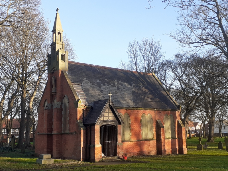
North Chapel Bishopwearmouth
Cemetery
GV II
Municipal cemetery chapel, originally Roman Catholic but now
used by all denominations. Possibly 1856 by Thomas Moore.
Brick with ashlar dressings; Welsh slate roof with bands of
Lakeland slate, terracotta ridge cresting, ashlar bellcote and
gable copings. 3-bay nave with S porch, one-bay apsed chancel,
defined by buttresses. Polygonal apse has hipped roof. Gabled
porch has double boarded doors under elliptical lintel and
timber framing to gable with cross finial to bargeboards.
Paired cusped lancets on sill string have alternate block
jambs; W elevation has 3 lancets separated by stepped
buttresses rising to triple bellcote with high pyramidal
spirelet and cross finial; 4-centred-arched cusped corbelling
to centre of bellcote forms canopy to eroded statue set
between buttresses on wall bracket.
Listing NGR: NZ3741756546
External links are from the relevant listing authority and, where applicable, Wikidata. Wikidata IDs may be related buildings as well as this specific building. If you want to add or update a link, you will need to do so by editing the Wikidata entry.


Other nearby listed buildings