Approximate Location Map
Large Map »
Latitude: 52.5873 / 52°35'14"N
Longitude: -2.1233 / 2°7'23"W
OS Eastings: 391743
OS Northings: 298835
OS Grid: SO917988
Mapcode National: GBR 1FJ.CX
Mapcode Global: WHBFZ.C74C
Plus Code: 9C4VHVPG+WM
Entry Name: Former Chubb's Lock Works
Listing Date: 31 March 1992
Grade: II
Source: Historic England
Source ID: 1279564
English Heritage Legacy ID: 378547
ID on this website: 101279564
Location: Wolverhampton, West Midlands, WV1
County: City of Wolverhampton
Electoral Ward/Division: St Peter's
Parish: Non Civil Parish
Built-Up Area: Wolverhampton
Traditional County: Staffordshire
Lieutenancy Area (Ceremonial County): West Midlands
Church of England Parish: Central Wolverhampton
Church of England Diocese: Lichfield
Tagged with: Building Architectural structure
WOLVERHAMPTON
SO9198NE RAILWAY STREET
895-1/12/300 (West side)
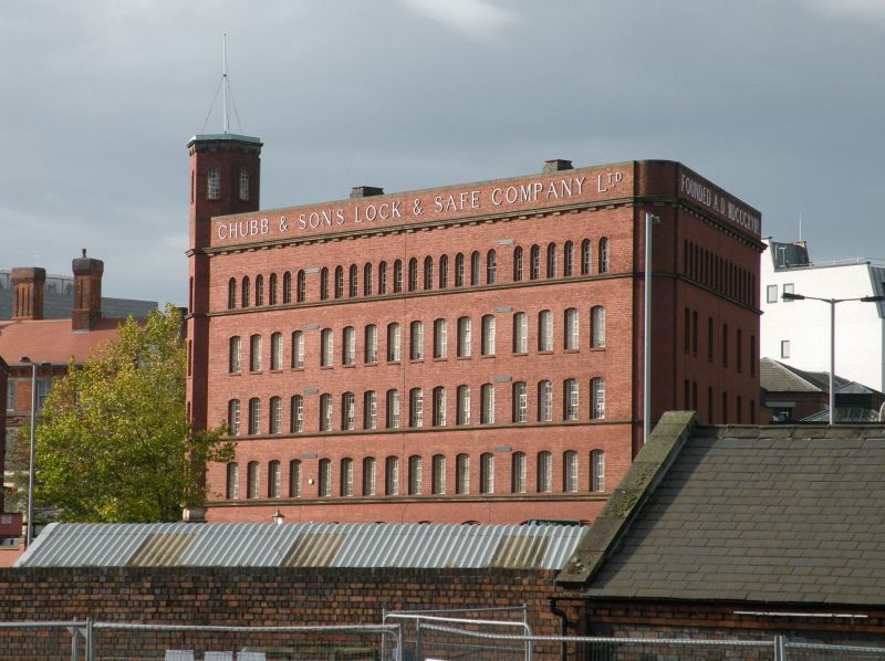
Former Chubb's Lock Works
GV II
Factory, being converted to new use at time of resurvey
(1990). 1898-9, extended early C20. By C.H.M. Mileham of
London. Red brick with ashlar dressings and parapeted roof;
later parts of stock brick with red brick dressings and slate
roof. 5 storeys; 16-window range. Sill courses to 1st, 2nd and
4th floors, top cornice and deep parapet with lettering. 8
large segmental-headed windows to ground floor have tripartite
frames with transom and small-paned glazing; upper floors have
windows with small-paned iron glazing: 1st floor has 16
segmental-headed windows, 2nd and 3rd floors the same, 4th
floor has 24 round-headed windows. Canted angle to Chubb
Street corner has hexagonal turret with round-headed windows.
Elliptical-headed entrance has ashlar surround and cornice and
battened door; panel with armorial bearing to ashlar moulding
to base of upper storeys. 9-window range to Chubb Street has 3
ground floor windows and segmental-headed cart entrance with
paired doors; 13 windows to 4th floor. Later 3-storey,
8-window, range to left has similar but simpler details;
paired windows to ground floor. 3-storey, 13-window range to
Fryer Street. Elevation to Long Street has 6-window range
continuing facade treatment and single-storey 4-window range;
4-window later range to right. An important example of a
building relating to one of Wolverhampton's major industries,
with important townscape value for the approaches to the town
centre.
(Booklet printed for the laying of the Foundation Stone:
1898-).
Listing NGR: SO9174398835
External links are from the relevant listing authority and, where applicable, Wikidata. Wikidata IDs may be related buildings as well as this specific building. If you want to add or update a link, you will need to do so by editing the Wikidata entry.


Other nearby listed buildings
