Approximate Location Map
Large Map »
Latitude: 51.2094 / 51°12'34"N
Longitude: -3.4822 / 3°28'55"W
OS Eastings: 296558
OS Northings: 146626
OS Grid: SS965466
Mapcode National: GBR LJ.41N4
Mapcode Global: VH5JY.LVGQ
Plus Code: 9C3R6G59+Q4
Entry Name: No 28 and Edgehill and Attached Wall
Listing Date: 28 October 1976
Last Amended: 30 September 1994
Grade: II
Source: Historic England
Source ID: 1279932
English Heritage Legacy ID: 391268
ID on this website: 101279932
Location: Higher Town, Somerset, TA24
County: Somerset
District: Somerset West and Taunton
Civil Parish: Minehead
Built-Up Area: Minehead
Traditional County: Somerset
Lieutenancy Area (Ceremonial County): Somerset
Tagged with: Building
MINEHEAD
SS9646 VICARAGE ROAD
900-1/3/109 (North West side)
28/10/76 No.28
and Edgehill and attached wall
(Formerly Listed as:
VICARAGE ROAD
(North West side)
No.28
and Edgehill)
II
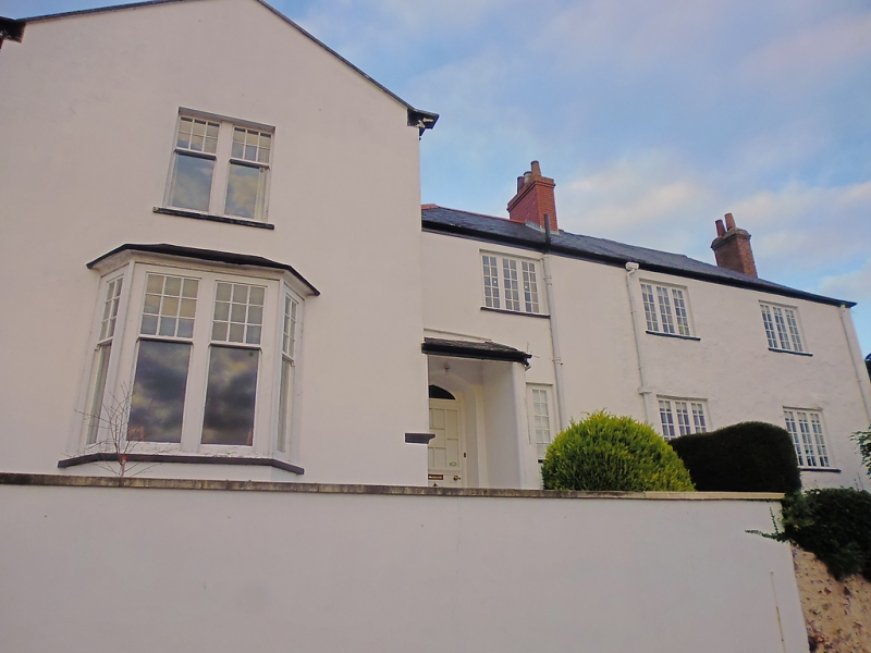
2 houses, formerly vicarage, set high above the road. Late C18
with mid C19 extension. Painted render over rubblestone, plain
tile roofs with brick stacks to sides, centre and rear.
L-shaped plan.
2 storeys; 4-window range. Built in 2 parts, the C18 vicarage
to the right is rectangular plan with a hipped roof and stacks
to left, right and rear. Three C19 large 3-light casement
windows to both floors to the front. The right return has a
C18 two-light leaded window to the first floor.The range to
the left is now part of Edgehill with a C20 lean-to porch to
the far left, adjacent to the projecting gable.
C19 Edgehill, to the left, is taller, with stone coping and
moulded kneelers to the forward-facing projecting gable.
Paired sash windows with small panes to the top sash and plate
glass to the lower; one to the first floor and to a splayed
bay to the ground floor, also to the right of the left return.
INTERIORS not inspected.
SUBSIDIARY FEATURES: a rubblestone retaining wall approx 3m
high and 50m long, front the buildings. That to Edgehill, to
the left, is rendered and painted.
Listing NGR: SS9655846626
External links are from the relevant listing authority and, where applicable, Wikidata. Wikidata IDs may be related buildings as well as this specific building. If you want to add or update a link, you will need to do so by editing the Wikidata entry.


Other nearby listed buildings
