Approximate Location Map
Large Map »
Latitude: 51.2044 / 51°12'15"N
Longitude: -3.4802 / 3°28'48"W
OS Eastings: 296690
OS Northings: 146066
OS Grid: SS966460
Mapcode National: GBR LJ.4G4D
Mapcode Global: VH5JY.MZJK
Plus Code: 9C3R6G39+QW
Entry Name: Old Dyehouse
Listing Date: 4 July 1952
Grade: II
Source: Historic England
Source ID: 1279985
English Heritage Legacy ID: 391129
ID on this website: 101279985
Location: Minehead, Somerset, TA24
County: Somerset
District: Somerset West and Taunton
Civil Parish: Minehead
Built-Up Area: Minehead
Traditional County: Somerset
Lieutenancy Area (Ceremonial County): Somerset
Tagged with: Architectural structure
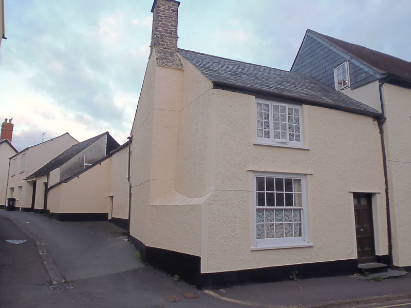
MINEHEAD
SS9646 BAMPTON STREET
900-1/3/4 (West side)
04/07/52 No.10
Old Dyehouse
GV II
House. Early C18. Render over cob or rubblestone, slate roof
with external rendered stack to left gable end off-set at the
ridge with a rubblestone shaft above. One-unit plan. 2
storeys; one-window range. A C19 three-light window at eaves
level set above a C19 ten/ten-pane sash window with a C19
six-panelled door to the right. INTERIOR not inspected.
Listing NGR: SS9669046066
External links are from the relevant listing authority and, where applicable, Wikidata. Wikidata IDs may be related buildings as well as this specific building. If you want to add or update a link, you will need to do so by editing the Wikidata entry.


Other nearby listed buildings
