Latitude: 52.0235 / 52°1'24"N
Longitude: 0.2395 / 0°14'22"E
OS Eastings: 553750
OS Northings: 238483
OS Grid: TL537384
Mapcode National: GBR MC3.1CK
Mapcode Global: VHHL4.3DFN
Plus Code: 9F4226FQ+9Q
Entry Name: 26, King Street
Listing Date: 28 November 1951
Last Amended: 31 October 1994
Grade: II
Source: Historic England
Source ID: 1280255
English Heritage Legacy ID: 370637
ID on this website: 101280255
Location: Saffron Walden, Uttlesford, Essex, CB10
County: Essex
District: Uttlesford
Civil Parish: Saffron Walden
Built-Up Area: Saffron Walden
Traditional County: Essex
Lieutenancy Area (Ceremonial County): Essex
Tagged with: Building
SAFFRON WALDEN
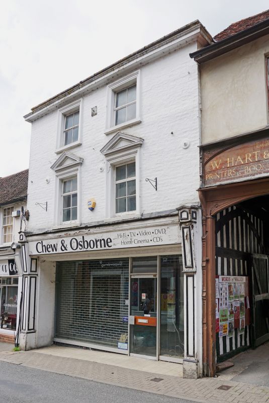
TL5338 KING STREET 669-1/1/253 (North side) 28/11/51 No.26 (Formerly Listed as: KING STREET (North side) Nos.22 AND 26 (Even))
GV II
House and shop. Early C16 and C19. Timber framing and brick, slate and peg-tiled roofs, long narrow plan running back from street. 3 storeys and cellars. Front S elevation: C19 brick, painted, first and second floor projecting, 2 window range, moulded stucco architraves, first floor with pediments and sash windows, roof set well back behind parapet. Ground floor, C20 shop with C19 end pilasters and fascia board, shop front all of plate glass. E, side elevation: early C16 carriageway to street (qv), and, behind, long range along alleyway with timber framing of close studding, partly surviving, particularly above a middle rail, and partly replaced by brick. Peg frequency suggests the former existence of a medieval shop immediately N of the carriageway. Windows scattered, ground floor, one C19 sliding sash, 4x2 panes, one C20 casement, one 3-light window, was sliding, glazing bars, 12x3 panes. First floor, C20 casement with glazing bars, 3x4 panes and one simple narrow window 1x3 panes. Some of the wall has C20 pargetting, especially towards rear. INTERIOR: rebuilt. This long range, together with the adjacent carriageway and Nos 20 and 20A (qv) has the shape of a typical large medieval inn.
Listing NGR: TL5375038483
External links are from the relevant listing authority and, where applicable, Wikidata. Wikidata IDs may be related buildings as well as this specific building. If you want to add or update a link, you will need to do so by editing the Wikidata entry.


Other nearby listed buildings