Approximate Location Map
Large Map »
Latitude: 51.2058 / 51°12'21"N
Longitude: -4.1279 / 4°7'40"W
OS Eastings: 251446
OS Northings: 147333
OS Grid: SS514473
Mapcode National: GBR KN.462S
Mapcode Global: VH4M4.DYLH
Plus Code: 9C3Q6V4C+8R
Entry Name: Holy Trinity Parish Hall and Attached Wall, Railings and Lamp Standard to South and South West
Listing Date: 12 March 1990
Last Amended: 14 March 1994
Grade: II
Source: Historic England
Source ID: 1281883
English Heritage Legacy ID: 390172
ID on this website: 101281883
Location: Ilfracombe, North Devon, EX34
County: Devon
District: North Devon
Civil Parish: Ilfracombe
Built-Up Area: Ilfracombe
Traditional County: Devon
Lieutenancy Area (Ceremonial County): Devon
Church of England Parish: Ilfracombe Holy Trinity
Church of England Diocese: Exeter
Tagged with: Church hall
ILFRACOMBE
SS5147 CHURCH ROAD
853-1/6/29 (West side)
12/03/90 Holy Trinity Parish Hall & attached
wall, railings & lamp standard to S
& SW
(Formerly Listed as:
CHURCH ROAD
(West side)
Holy Trinity Parish Hall)
GV II
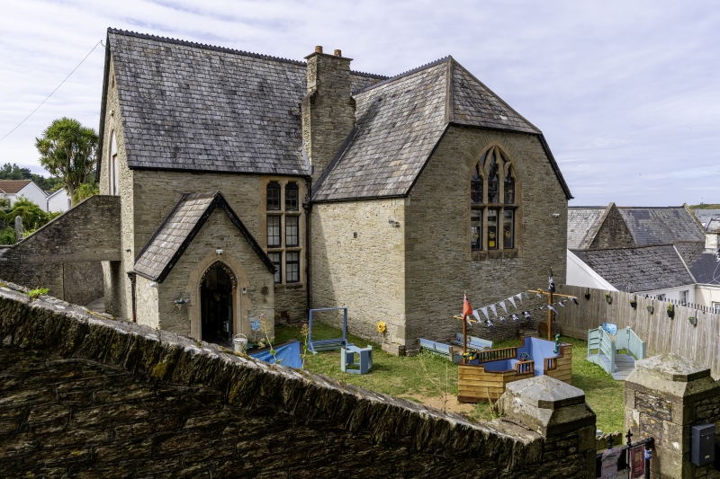
Parish hall, formerly a school. Dated 1862; probably by Foster
& Wood of Bristol. Designed in a simple Gothic style.
MATERIALS: coursed and squared slatestone rubble with
limestone detailing. Slated roof, half-hipped on the south
side; blue crested ridge riles. Large stone chimney
(heightened in red brick) on south-west corner.
PLAN: L-shaped plan: the main range runs east-west with wing
and entrance porch on the south, lean-to on the north.
EXTERIOR: seems to have been single-storeyed originally with a
gallery at the west end; upper floor now inserted. Large,
pointed, mullioned and transomed windows, with cusped heads to
the lights, in east gable wall of main range and south gable
wall of wing. Similar window in south wall of main range, but
with flat head and shouldered arches to the upper lights. 2
single light windows with shouldered arches in the east wall,
together with one in the shape of a trefoil.
Gabled porch has moulded, pointed stone doorway; inner door
with 6 chamfered panels (3 above and 3 below) and matching
reveals. Doorway in west gable of main range has a pointed
stone arch; 4-panelled double doors. It is reached by a stone
bridge from higher ground at the rear of the building. North
front is plain; C20 dormer windows inserted.
INTERIOR not inspected.
SUBSIDIARY FEATURES: Boundary wall is of different build from
the school itself, which it abuts. Stone rubble with coping of
stones on edge, heightened on the north and north-west sides.
The best work is on the south and south-east sides, facing
Church Road and the steps up to the churchyard.
Opposite the school porch the wall breaks to provide a
gateway, the jambs having quoins of dressed stone and the wall
tops decorated with shaped pieces of stone as if they were
gate piers. Good iron gates with uprights having fleurs-de-lis
finials (one missing). Similar railing on east side, extending
along the wall top as far as the school building. On the wall
at the south-west corner of the curtilage stands a C19 iron
lamp standard with twisted and fluted shaft; lantern replaced
in C20.
The iron railing along the causeway immediately east of the
parish hall is separately listed.
HISTORY: according to The Builder, 1859 (p.7), the school was
then expected to be built before the end of the year to
designs by Foster & Wood of Bristol. Mr Richard Bligh of
Ilfracombe was to pay for the building at a cost of »600-700,
the school committee purchasing the site and fitting the
building after completion. A datestone of 1862, however, shows
that work was delayed and it should not be assumed that Foster
& Wood's designs were eventually used.
Listing NGR: SS5144547334
External links are from the relevant listing authority and, where applicable, Wikidata. Wikidata IDs may be related buildings as well as this specific building. If you want to add or update a link, you will need to do so by editing the Wikidata entry.


Other nearby listed buildings
