Approximate Location Map
Large Map »
Latitude: 53.3874 / 53°23'14"N
Longitude: -3.0251 / 3°1'30"W
OS Eastings: 331920
OS Northings: 388326
OS Grid: SJ319883
Mapcode National: GBR 7Y98.WF
Mapcode Global: WH87D.H4Q0
Plus Code: 9C5R9XPF+WX
Entry Name: 8, Lowwood Road
Listing Date: 21 July 1987
Last Amended: 10 August 1992
Grade: II
Source: Historic England
Source ID: 1282604
English Heritage Legacy ID: 389245
ID on this website: 101282604
Location: Wirral, Merseyside, CH41
County: Wirral
Electoral Ward/Division: Birkenhead and Tranmere
Parish: Non Civil Parish
Built-Up Area: Birkenhead
Traditional County: Cheshire
Lieutenancy Area (Ceremonial County): Merseyside
Church of England Parish: Birkenhead Christ the King
Church of England Diocese: Chester
Tagged with: Building
BIRKENHEAD
SJ3188 LOWWOOD ROAD
789-1/11/97 (North side)
21/07/87 No.8
(Formerly Listed as:
LOWWOOD ROAD
(North side)
No.8
Laurel Villa)
GV II
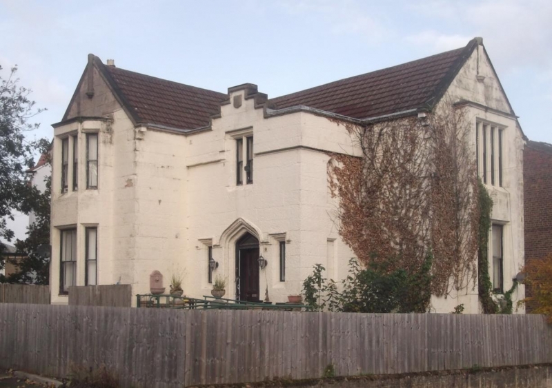
House. c1840. Probably by Walter Scott. Lined out stucco with
concrete tiled roof. 2 storeys, L-plan with advanced
full-height gabled porch in the angle. Crow-stepped gable to
porch with Tudor arched doorway with hood mould continuous
over flanking lancet lights. 2-light mullioned window above
with hood mould. Stone shield and finial at gable apex, said
to be the crest of Lord Baden Powell. Projecting gabled wing
to left has full-height canted bay window with sashes divided
by mullions to first floor, the larger lower sash window
inserted in the later C19. Coping to gable above. Coped gabled
range to right has full height squared bay with 2- and 4-light
mullioned windows. Side and rear wall stacks. Interior said to
contain open string stair with stick balustrade and moulded
newels, and sky-light above stair with painted glass panel
depicting rural scene of cows by river. The house forms part
of the original Clifton park development, laid out by Scott
during the 1840's.
Listing NGR: SJ3192088326
External links are from the relevant listing authority and, where applicable, Wikidata. Wikidata IDs may be related buildings as well as this specific building. If you want to add or update a link, you will need to do so by editing the Wikidata entry.


Other nearby listed buildings
