Approximate Location Map
Large Map »
Latitude: 53.3874 / 53°23'14"N
Longitude: -3.0395 / 3°2'22"W
OS Eastings: 330958
OS Northings: 388347
OS Grid: SJ309883
Mapcode National: GBR 7Y68.RF
Mapcode Global: WH87D.83VY
Plus Code: 9C5R9XP6+X5
Entry Name: Kenyon Terrace
Listing Date: 28 March 1974
Grade: II
Source: Historic England
Source ID: 1282611
English Heritage Legacy ID: 389176
ID on this website: 101282611
Location: Claughton, Wirral, Merseyside, CH43
County: Wirral
Electoral Ward/Division: Claughton
Parish: Non Civil Parish
Built-Up Area: Birkenhead
Traditional County: Cheshire
Lieutenancy Area (Ceremonial County): Merseyside
Church of England Parish: Birkenhead Christ the King
Church of England Diocese: Chester
Tagged with: Building Terrace of houses
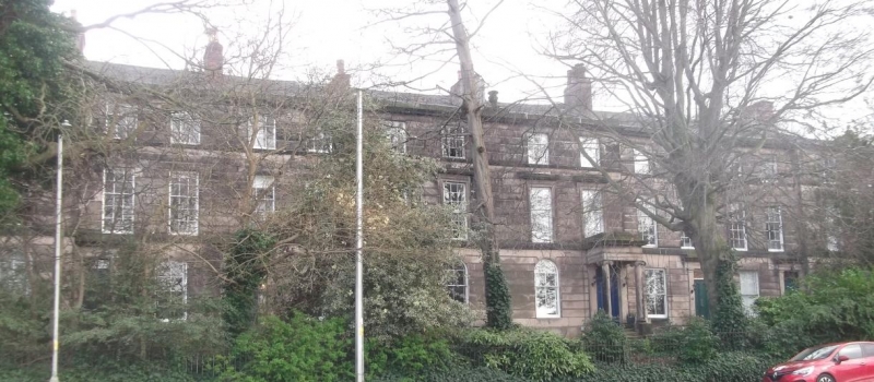
BIRKENHEAD
SJ3088 DEVONSHIRE ROAD, Claughton
789-1/10/197 (South side)
28/03/74 Nos.1-15
Kenyon Terrace
GV II
Terrace of 8 dwellings. c1840. Probably by Charles Reed.
Ashlar-faced with Welsh slate roof. 3 storeys, planned as a
symmetrical series (2-4-4-4-2), the outer and central sections
advanced. Outer units have side entrances in pedimented
doorcases in the centre of a 3-bay return elevation. Inner
dwellings have narrower plan, with doorway and single window
on ground floor. Rusticated ground floor, with 4-panelled
doors with overlights in stressed architraves. Upper windows
have architraves with stressed entablatures carried on console
brackets. 12-pane sashes renewed to ground floor, and
round-arched windows in outer and central dwellings. Central
pair further stressed with doors in Ionic entrance porches.
Cornice with urn and scroll decoration at each end, part now
missing. Gable and axial stacks. The row is one of three
ranges built as a single development and forming part of the
original development of Claughton, laid out by Reed for Sir
William Jackson in the early 1840's.
Listing NGR: SJ3095788347
External links are from the relevant listing authority and, where applicable, Wikidata. Wikidata IDs may be related buildings as well as this specific building. If you want to add or update a link, you will need to do so by editing the Wikidata entry.


Other nearby listed buildings
