Approximate Location Map
Large Map »
Latitude: 51.9917 / 51°59'30"N
Longitude: -2.1621 / 2°9'43"W
OS Eastings: 388968
OS Northings: 232594
OS Grid: SO889325
Mapcode National: GBR 1JR.073
Mapcode Global: VH93T.G6VH
Plus Code: 9C3VXRRQ+M5
Entry Name: Boundary Wall from Folly Cottage to Numbers 11, 12 and 13 Mill Bank
Listing Date: 25 April 1994
Grade: II
Source: Historic England
Source ID: 1282754
English Heritage Legacy ID: 376919
ID on this website: 101282754
Location: Tewkesbury, Gloucestershire, GL20
County: Gloucestershire
District: Tewkesbury
Civil Parish: Tewkesbury
Built-Up Area: Tewkesbury
Traditional County: Gloucestershire
Lieutenancy Area (Ceremonial County): Gloucestershire
Church of England Parish: Tewkesbury St Mary the Virgin (Tewkesbury Abbey)
Church of England Diocese: Gloucester
Tagged with: Wall
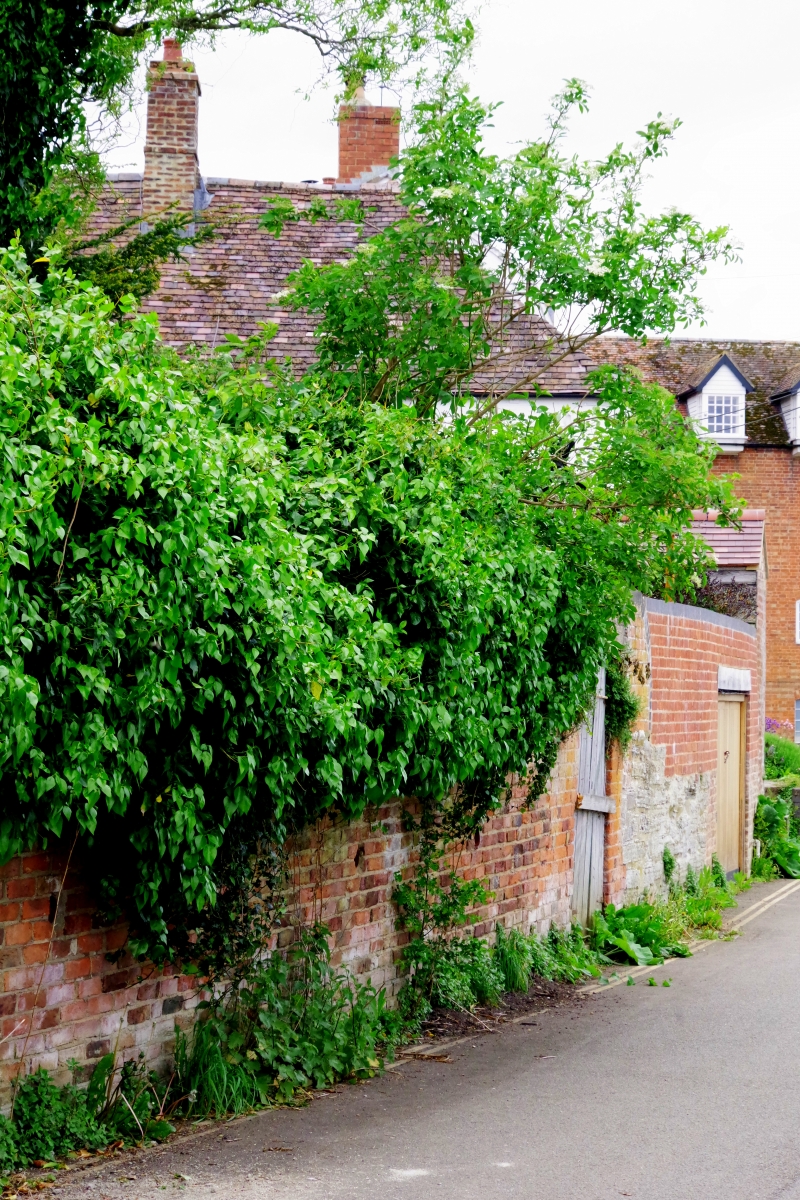
TEWKESBURY
SO83SE ST MARY'S ROAD
859-1/2/338 (South East side)
Boundary wall from Folly Cottage to
Nos.11, 12 and 13 Mill Bank
GV II
Run of boundary walls at end of plots to Church Street. C18
and C19. Brick and stone. A series of 7 sections of wall,
forming a continuous connected boundary immediately on the
street which is here generally lower than the plots contained.
From the right end (SW):
(a) C18 brick with some sections in large lias block, probably
of C16 or C17 date, approx 1.5m high, but rising at right end
to approx 3m. The wall returns opposite Nos 9 & 10, Mill Bank
(qv) to the gable end of Nos 11-13 (qv).
(b) a long (approx 15m) stretch of C19 brick wall, mainly in
stretchers, to a blue brick coping at approx 2.75m from road
level, includes a wide plank door to a concrete lintel at
right-hand end.
(c) C18 Flemish bond brickwork, coping concealed by ivy
growth. Approx 7m run, with straight joints at each end, this
retains the Baptist Church graveyard.
(d) C18 Flemish bond brickwork, approx 6m run and 3m high,
containing a wide pair of plank doors.
(e) English garden wall bond, approx 8m run, to brick-on-edge
coping at approx 2.5m. Straight joints each end.
(f) Boundary wall to 'The Hamlet' (not included) in English
garden wall bond. Total approx 9m run, includes garage doors
under brick-on-edge coping, right, but drops to left with
concrete coping, and plank door;
(g) Boundary wall abutting Folly Cottage (not included) at the
left-hand end. C19 English garden wall bond to approx 2.25m
with sandstone coping, but swept up to a capped pier with
sandstone pyramidal capping, at each end.
Because of the existence here of the River Avon, beyond which
lies the open area of The Ham, this wall is a significant
boundary marking the extent of the built-up historic town; it
is also important visually as a boundary to the varied plots
which it retains.
Listing NGR: SO8896832593
External links are from the relevant listing authority and, where applicable, Wikidata. Wikidata IDs may be related buildings as well as this specific building. If you want to add or update a link, you will need to do so by editing the Wikidata entry.


Other nearby listed buildings
