Approximate Location Map
Large Map »
Latitude: 51.99 / 51°59'24"N
Longitude: -2.1607 / 2°9'38"W
OS Eastings: 389060
OS Northings: 232411
OS Grid: SO890324
Mapcode National: GBR 1JR.6JG
Mapcode Global: VH93T.H7KS
Plus Code: 9C3VXRRQ+2P
Entry Name: Boundary Wall, South of Church of St Mary
Listing Date: 25 April 1994
Grade: II
Source: Historic England
Source ID: 1282806
English Heritage Legacy ID: 376553
ID on this website: 101282806
Location: St Mary's Abbey Church, Tewkesbury, Gloucestershire, GL20
County: Gloucestershire
District: Tewkesbury
Civil Parish: Tewkesbury
Built-Up Area: Tewkesbury
Traditional County: Gloucestershire
Lieutenancy Area (Ceremonial County): Gloucestershire
Church of England Parish: Tewkesbury St Mary the Virgin (Tewkesbury Abbey)
Church of England Diocese: Gloucester
Tagged with: Wall
TEWKESBURY
SO8932 ABBEY PRECINCTS
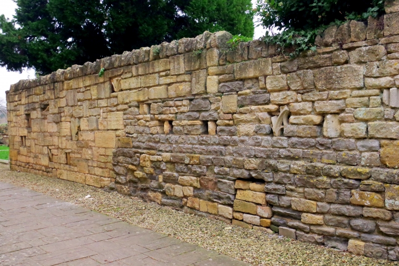
859-1/6/350 Boundary wall, south of Church of St
Mary
GV II
Length of boundary wall. Undated, incorporates medieval
fragments. Coursed limestone and lias. A length of boundary
wall, from approx 1.5m to approx 2.5m high, with rough
stone-on-edge copings, but in parts overgrown (November 1991);
approx 75m total length. It lies parallel to and approx 10m S
of the S wall of the Abbey south aisle. The wall returns at
the SW corner of the Abbey, where it is stopped to the archway
with gate linked to Abbey House (qv), and at its E end it
curves away towards the south near the SW corner of the
transept. It is stopped to the S boundary fence to the Abbey.
The wall probably does not follow a significant historical
line, as the former monastic buildings would have occupied
this area, but it does have various fragments built in which
were part of the medieval fabric, and ought therefore to be
retained.
Listing NGR: SO8906832414
External links are from the relevant listing authority and, where applicable, Wikidata. Wikidata IDs may be related buildings as well as this specific building. If you want to add or update a link, you will need to do so by editing the Wikidata entry.


Other nearby listed buildings
