Latitude: 53.478 / 53°28'40"N
Longitude: -2.2495 / 2°14'58"W
OS Eastings: 383535
OS Northings: 397951
OS Grid: SJ835979
Mapcode National: GBR DHJ.L6
Mapcode Global: WHB9G.FV01
Plus Code: 9C5VFQH2+65
Entry Name: Former Entrance to Deansgate Goods Station Including Numbers 223 to 233
Listing Date: 23 November 1979
Grade: II
Source: Historic England
Source ID: 1282974
English Heritage Legacy ID: 388093
ID on this website: 101282974
Location: Manchester, Greater Manchester, M3
County: Manchester
Electoral Ward/Division: City Centre
Parish: Non Civil Parish
Built-Up Area: Manchester
Traditional County: Lancashire
Lieutenancy Area (Ceremonial County): Greater Manchester
Church of England Parish: Manchester St Ann
Church of England Diocese: Manchester
Tagged with: Building
MANCHESTER
SJ8397NE DEANSGATE 698-1/31/109 (East side) 23/11/79 Nos.223 TO 233 (Odd) Former entrance to Deansgate Goods Station including Nos 223 to 233
GV II
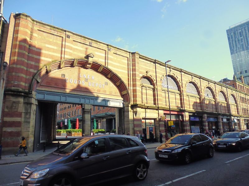
Entrance to former railway goods station. 1899. Red brick with sandstone dressings. A screen wall comprising 7 bays of blank arcading divided by giant pilasters. Stone bands, frieze, cornice and blocking-course. In the left bay is the former station entrance (now pedestrian access to car park) with twin segmental vaults to the covered way which is set at an angle and fronted above by a massive blind segmental arch of 4 moulded brick rings with pedimented stone keyblock and radiating stone blocks of similar design; splayed pilasters at either side of covered way which is now blocked on right-hand side. The tympanum has raised block lettering "L.N.E.R. GOODS DEPOT". The remaining 6 bays (including a half-bay to right of entrance) have blank arches of similar character, with C20 shop-fronts at ground floor, and the tympanum of each arch with raised lettering giving the destinations of the railway. Forms group with Nos 235 to 291 (odd) which form a very long continuation to the right (q.v.).
Listing NGR: SJ8353597951
External links are from the relevant listing authority and, where applicable, Wikidata. Wikidata IDs may be related buildings as well as this specific building. If you want to add or update a link, you will need to do so by editing the Wikidata entry.


Other nearby listed buildings