Approximate Location Map
Large Map »
Latitude: 52.3558 / 52°21'21"N
Longitude: 0.8017 / 0°48'5"E
OS Eastings: 590889
OS Northings: 276781
OS Grid: TL908767
Mapcode National: GBR RF2.CGQ
Mapcode Global: VHKCS.V15V
Plus Code: 9F429R42+8M
Entry Name: Field Farmhouse
Listing Date: 14 July 1955
Grade: II
Source: Historic England
Source ID: 1284781
English Heritage Legacy ID: 284041
ID on this website: 101284781
Location: Fakenham Magna, West Suffolk, IP24
County: Suffolk
District: West Suffolk
Civil Parish: Fakenham Magna
Traditional County: Suffolk
Lieutenancy Area (Ceremonial County): Suffolk
Church of England Parish: Fakenham Magna St Peter
Church of England Diocese: St.Edmundsbury and Ipswich
Tagged with: Farmhouse
TL 97 NW
2/64
14.7.55
FAKENHAM MAGNA
THETFORD ROAD (EAST SIDE)
Field Farmhouse
GV
II
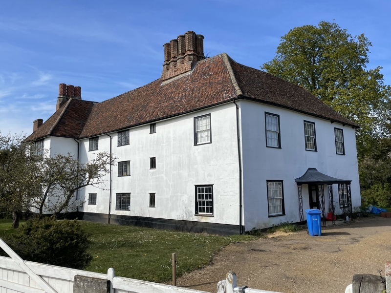
Farmhouse. Late C16, early C17 and late C18/early C19. Timber-framed,
rendered and lined: plaintiles to front slopes of roof, black-glazed pantiles
to rear. The house is of irregular form, and unusually high. The C16 main
range is aligned north-south. 3 storeys and attics. Large internal chimney-
stack with 8 octagonal shafts, moulded at cap and base. 2 early C18 3-light
casement windows with square leaded panes to first and second storeys, one
similar window and one C20 replacement window on ground storey, and one small-
paned sash window in flush frame at the south end. To the north of the main
range, and apparently contemporary with it, a cross-wing, aligned east-west. 3
storeys. A chimney-stack, with 3 shafts matching those in the main range, is
set just within the frame of the north wall. At the south end of the main
range, a wing aligned east-west, with a new principal front was added in the
early C19. 2 storeys, 3 bays. Fully hipped roof. 3 window range: small-paned
sashes in flush frames. Central half-glazed entrance door, recessed, in a
reeded surround, with panelled sides to jambs. 3-sided cast iron openwork
porch with tented lead-covered roof. Extensions at rear: in the north-east
angle, a small early C17 2-storey wing in red brick with a 3-light ovolo-
moulded mullion-and-transome window in the upper part of the gable. To the
north of this, a 2-storey lean-to, mid C19, in red brick with black-glazed
pantiled roof: casement windows with arched heads to brickwork. To the east, a
single-storey lean-to, mid C19, in flint rubble with pantiled roof.
Listing NGR: TL9088976781
External links are from the relevant listing authority and, where applicable, Wikidata. Wikidata IDs may be related buildings as well as this specific building. If you want to add or update a link, you will need to do so by editing the Wikidata entry.


Other nearby listed buildings
