Approximate Location Map
Large Map »
Latitude: 50.8327 / 50°49'57"N
Longitude: -0.2753 / 0°16'31"W
OS Eastings: 521552
OS Northings: 105105
OS Grid: TQ215051
Mapcode National: GBR HMF.P79
Mapcode Global: FRA B69W.YBM
Plus Code: 9C2XRPMF+3V
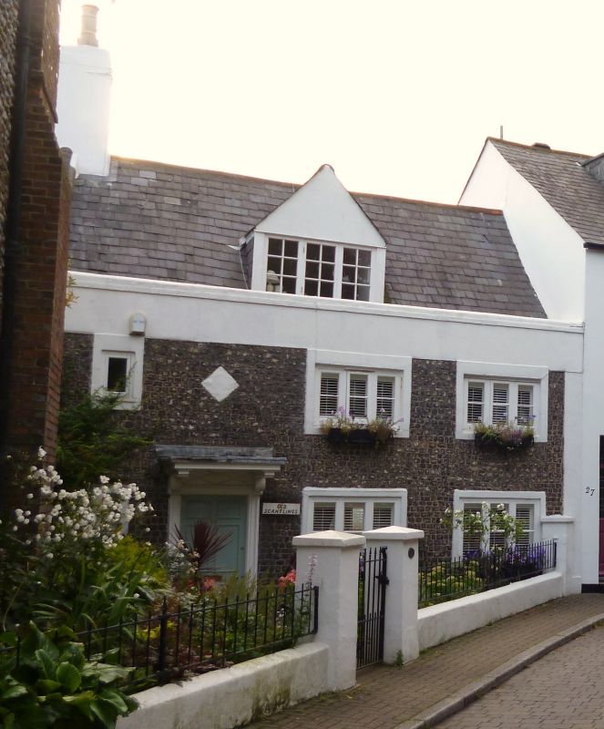
Entry Name: Old Scantlings
Listing Date: 29 September 1972
Last Amended: 27 July 1984
Grade: II
Source: Historic England
Source ID: 1286456
English Heritage Legacy ID: 297278
ID on this website: 101286456
Location: Shoreham-by-Sea, Adur, West Sussex, BN43
County: West Sussex
District: Adur
Electoral Ward/Division: St Mary's
Parish: Non Civil Parish
Built-Up Area: Shoreham-by-Sea
Traditional County: Sussex
Lieutenancy Area (Ceremonial County): West Sussex
Church of England Parish: New Shoreham St Mary de Haura
Church of England Diocese: Chichester
Tagged with: Architectural structure
In the entry for:
SHOREHAM-BY-SEA CHURCH STREET
7/89 (west side)
Old Scantlings
The item shall be changed to read: CHURCH STREET
(west side)
Old Scantlings
(formerly listed
as No 26)
The former listing date shall be added to read: 29/9/72
------------------------------------
SHOREHAM-BY-SEA CHURCH STREET
TQ 2105 SE
7/89 (west side)
Old Scantlings
GV II
Cottage. Mid-C18. Flint with rendered quoins and dressings. Coped parapet to slate
roof with large central gabled dormers and end stack to left. Two storeys and attic;
irregular 3 window front, casements in wide rendered surrounds. Entrance to left with
panelled door in moulded wooden surround; flat hood on brackets over.
Listing NGR: TQ2155205105
External links are from the relevant listing authority and, where applicable, Wikidata. Wikidata IDs may be related buildings as well as this specific building. If you want to add or update a link, you will need to do so by editing the Wikidata entry.


Other nearby listed buildings
