Approximate Location Map
Large Map »
Latitude: 53.1442 / 53°8'39"N
Longitude: -1.1993 / 1°11'57"W
OS Eastings: 453651
OS Northings: 361082
OS Grid: SK536610
Mapcode National: GBR 8F5.X5S
Mapcode Global: WHDFZ.K73F
Plus Code: 9C5W4RV2+M7
Entry Name: The Old Parsonage
Listing Date: 19 December 1955
Grade: II
Source: Historic England
Source ID: 1288395
English Heritage Legacy ID: 391733
ID on this website: 101288395
Location: Mansfield, Nottinghamshire, NG18
County: Nottinghamshire
District: Mansfield
Electoral Ward/Division: Woodlands
Parish: Non Civil Parish
Built-Up Area: Mansfield
Traditional County: Nottinghamshire
Lieutenancy Area (Ceremonial County): Nottinghamshire
Church of England Parish: Mansfield St John with St Mary
Church of England Diocese: Southwell and Nottingham
Tagged with: Clergy house
MANSFIELD
SK5361 MILL WALK
924-1/5/73 (East side)
19/12/55 The Old Parsonage
II
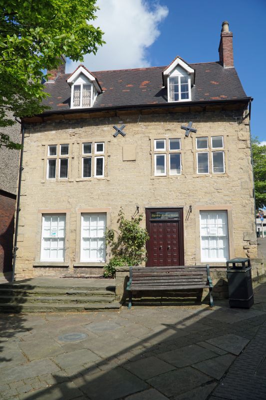
Also known as: Old Meeting House MILL WALK.
House, now offices. Mid C17, with mid and late C19 and late
C20 alterations. Coursed squared stone with brick gables,
ashlar dressings and steep pitched plain tile roof with 2
brick gable stacks. Rear wing has pantile roof and single
ridge stack.
2 storeys plus attics; 4-window range, with 2 pairs of stone
flush-mullioned cross casements with projecting surrounds.
Above, 2 late C19 gabled dormers with 2-light casements.
Below, off-centre late C20 glazed double door and overlight,
flanked to left by two 12-pane sashes and to right by a
similar sash. These windows have projecting surrounds.
Rear wing has to left, a 3-light Yorkshire sash and to right,
a 5-light casement with stone flush mullions, the centre light
blocked. Below, to left, a stone doorcase and a plain
casement, and to right, a stone mullioned 5-light casement,
also with the centre light blocked.
HISTORICAL NOTE: in 1666 the house was occupied by Robert
Porter, and meetings of the Unitarian community began there.
(Buildings of England: Pevsner N & Williamson E:
Nottinghamshire: Harmondsworth: 1979-: 169).
Listing NGR: SK5365161082
External links are from the relevant listing authority and, where applicable, Wikidata. Wikidata IDs may be related buildings as well as this specific building. If you want to add or update a link, you will need to do so by editing the Wikidata entry.


Other nearby listed buildings
