Approximate Location Map
Large Map »
Latitude: 51.4853 / 51°29'6"N
Longitude: -0.0251 / 0°1'30"W
OS Eastings: 537223
OS Northings: 178106
OS Grid: TQ372781
Mapcode National: GBR K6.4CS
Mapcode Global: VHGR1.JX3S
Plus Code: 9C3XFXPF+4X
Entry Name: Eastern Boundary Wall to the former Royal Dockyard, Deptford
Listing Date: 13 February 1995
Last Amended: 25 July 2019
Grade: II
Source: Historic England
Source ID: 1288622
English Heritage Legacy ID: 399183
ID on this website: 101288622
Location: Millwall, Lewisham, London, SE8
County: London
District: Lewisham
Electoral Ward/Division: Evelyn
Parish: Non Civil Parish
Built-Up Area: Lewisham
Traditional County: Kent
Lieutenancy Area (Ceremonial County): Greater London
Church of England Parish: Deptford St Nicholas and St Luke
Church of England Diocese: Southwark
Tagged with: Wall
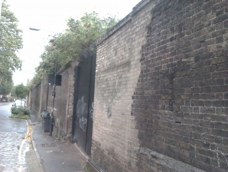
A late-C18 brick boundary wall, which was extended in the early C19, and altered in the C20. The wall formed part of the eastern boundary to the former Deptford Royal Dockyard.
A late-C18 brick boundary wall, which was extended in the early C19, and altered in the C20. The wall formed part of the eastern boundary to the former Deptford Royal Dockyard.
MATERIALS: mixed-stock, yellow, brown and red brick in English bond, with grey engineering bricks.
PLAN: the wall runs southward from the Thames, along Watergate Street, for approximately 200m. It is formed of two distinct sections (north and south), which are divided by a vehicle entrance at the intersection of Watergate and Borthwick Street.
DESCRIPTION: the eastern face of the wall is primarily described, as viewed from Watergate Street. The wall is substantial, standing around 6m high, and 1m in depth.
Northern section
This section is around 100m in length. At the northern end, it terminates at the river wall. The majority of the boundary wall has a coping of angled, mixed-stock brick, surmounting a course of cogged bricks, however this has been removed from the top of wall for the last 10m at either end of this section. Just above the road level, there is a single course of grey, chamfered engineering bricks, which is laid above a C20 rendered plinth. There are two, former pedestrian entrances with retained brick segmental arches, however both examples are now blocked-up with later brickwork. Towards the centre of the wall, an outbuilding of the former Master Shipwright's House is attached to the west face.
At the southern end of this section (where the wall kinks to the south-east), there is around a 10m run of timber filet inserted into the brickwork (presumably for attaching market advertising posters). The southern end of this section is terminated by a vehicle entrance with late-C20, functional metal gates*, which are located opposite Borthwick Street. Around 5m of the wall to the northern side of this entrance is heavily patched, probably as a result of cutting the vehicle entrance.
Southern section
The southern section of the wall is also around 100m in length and extends southward from the vehicle entrance. Just above the road level, there is a single course of grey, chamfered engineering bricks, which is laid above a C20 rendered plinth. Towards the northern end of the wall, there is a run of around 10m of timber filet, inserted into the brickwork.
Broadly within the centre of this section of the wall, but offset to the northern end, there is a projection of two pilasters, which probably correspond with the former projecting entrance to the dockyard known as the 'Clerk of the Checks Gate'. They extend above the surrounding coping, and have been rebuilt. The southern example is formed of London stock brick (probably C20), and the northern example is consistent with the rest of the wall in this section (late-C18 or early-C19). Between the pilasters towards the top of the wall, there is a course of header bricks, and the infill brick below also appears to be late-C18 or early-C19. Either side, the wall has a coping of angled mixed-stock bricks; the north side has a course of cogged bricks; the south side has a course of flat headers. On the west side of the wall there is a late C20, brick, storage shed*, and evidence of a former wall, running west.
At the southern end of the southern section of the boundary wall, the last 20m is clearly of a later phase of build (probably early-C20) and does not have a plinth, or a course of engineering bricks. It is surmounted by a bed of horizontal tiles, and finished with a coping of render. Towards the northern end on the east side, there is a brick pilaster, and the top of the wall curves gently downward towards the southern end. On the western face of the wall at the point of transition to the later phase of build, there is evidence of a former wall running west, and a late C20, brick, storage shed*.
* Pursuant to s1 (5A) of the Planning (Listed Buildings and Conservation Areas) Act 1990 (‘the Act’) it is declared that these aforementioned features are not of special architectural or historic interest. However any works which have the potential to affect the character of the listed building as a building of special architectural or historic interest may still require listed building consent and this is a matter for the LPA to determine.
The Royal Dockyard, Deptford was established by Henry VIII around 1513. His accession in 1509 marked a very considerable programme of naval expansion. Woolwich Dockyard was established in 1512, and in 1513 Henry began the development of Deptford by building a great storehouse; by the 1540s the 'King's Yard' at Deptford had become by far the most important royal dockyard nationally for the construction and repair of warships. Sir Francis Drake was knighted here in 1581, and his Golden Hind was exhibited here for over 70 years.
In the C17, Deptford was the second major centre for shipbuilding after Chatham, which was established under Elizabeth I, and gained pre-eminence in this respect. The Navy Board appointed a Master Shipwright in both places, and it was to Deptford that Tsar Peter the Great came for three months in 1698 to learn shipbuilding techniques. Its proximity to the Navy Board Office in the City of London meant that it was frequently chosen for experimental construction. However, the shifting of hostilities to France and Spain in the C18 meant that Portsmouth and Plymouth gained pre-eminence.
A number of well-known vessels were fitted out at Deptford, including Captain Cook's Endeavour and Discovery, as well as ships used in Nelson's campaigns. Despite navigational difficulties due to the silting up of the Thames, and the yard's consequent inability to service larger ships, further expansion took place in the C18 when it reached an area of some 30 acres. It fell into decline after 1815, closing in 1869, when the site was acquired by the Corporation of London for use as London's Foreign Cattle Market.
The extant boundary wall to the former Royal Dockyard Deptford, marks part of its eastern extent at the time of its closing in 1869. A historic map of 1668 shows the original eastern boundary of the dockyard to have been formed by the rear of the former Master Shipwright's House (National Heritage List for England (NHLE) reference 1213984, listed at Grade II*), and further to the south, a long, projecting entrance (known as the 'Clerk of Checks') which appears to terminate at the position of a pair of extant pilasters, which are located towards the centre (but offset to the north) of the southern section of the boundary wall. Drawings of the gatehouse, dated 1698, show it to have been two-storey and Classical in character.
By 1774, historic mapping shows a new boundary wall in two sections, located around 50m further east; the northern extent was around 50m in length and connected to new outbuildings at the rear of the Master Shipwright's House; the southern extent was also around 50m in length and fronted a quadrangle around a garden, with the northern side formed by the long projecting entrance. This arrangement is also confirmed by two other late-C18 maps and one of 1806-1810.
A historic map of 1828 shows the full extent of the extant wall, effectively joining up the original southern and northern sections to form a continuous and linear structure. By 1869, the former, long projecting entrance is shown as a carpenters workshop. A 1904 map continues to show this arrangement, but by the later C20 the north, south and west walls of the quadrangle had been removed. Furthermore, a vehicle entrance was cut into the wall to the north of the former projecting entrance, and in the northern section, two former pedestrian entrances were bricked-up.
At its far southern extent, the last 10m of the wall is probably late-C19 or early-C20, and is terminated by a separate, red-brick wall of later-C20 date. At the far northern extent of the boundary wall, it joins the Grade II-listed river wall (NHLE 1416575). The base of the boundary wall along its length, has been reinforced by C19/C20 engineering bricks and a rendered plinth.
The site suffered extensive destruction in the Second World War, and was redeveloped as warehousing known as Convoy's Wharf in the 1950s, when the bomb-damaged Tudor storehouse was demolished (its below ground remains are a scheduled monument). The doorway to the storehouse, together with a date stone, were removed to the Bartlett Building of University College London in Bloomsbury in 1954 and subsequently boxed in. However, in 2014, both the doorway and the date stone were again revealed and can now be viewed.
The Eastern Boundary Wall to the former Royal Dockyard, Deptford, is listed at Grade II for the following principal reasons:
Architectural interest:
* as a substantial and well-built section of a predominantly early-C19 boundary wall;
* it retains some late-C18, and a significant portion of early-C19 fabric, including well-documented enlargement and alterations.
Historic interest:
* it is among the last surviving visible fabric attesting to the presence of the Royal Dockyard at Deptford, a site of immense importance in Britain’s ascendancy as a naval power.
Group value:
* with designated buildings and structures from the Royal Dockyard, most notably the former Master Shipwright’s House (Grade II*), and the adjoining River Wall to former Royal Dockyard (Grade II).
External links are from the relevant listing authority and, where applicable, Wikidata. Wikidata IDs may be related buildings as well as this specific building. If you want to add or update a link, you will need to do so by editing the Wikidata entry.


Other nearby listed buildings
