Approximate Location Map
Large Map »
Latitude: 51.4885 / 51°29'18"N
Longitude: -2.4343 / 2°26'3"W
OS Eastings: 369938
OS Northings: 176703
OS Grid: ST699767
Mapcode National: GBR JY.KGCC
Mapcode Global: VH88J.RVF9
Plus Code: 9C3VFHQ8+97
Entry Name: Court Farmhouse
Listing Date: 15 August 1985
Grade: II
Source: Historic England
Source ID: 1289329
English Heritage Legacy ID: 397423
ID on this website: 101289329
Location: Pucklechurch, South Gloucestershire, BS16
County: South Gloucestershire
Civil Parish: Pucklechurch
Built-Up Area: Pucklechurch
Traditional County: Gloucestershire
Lieutenancy Area (Ceremonial County): Gloucestershire
Church of England Parish: Pucklechurch and Abson
Church of England Diocese: Bristol
Tagged with: Farmhouse
ST 67 NE PUCKLECHURCH C.P. WESTERLEIGH ROAD (west side)
4/220 Court Farmhouse
G.V. II
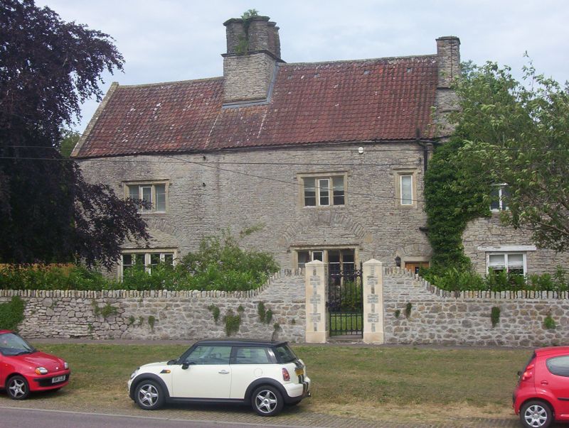
Farmhouse. Late C16/early C17, with later alterations. Coursed limestone
rubble with stone dressings, partly rendered, pantiled roof with coped verges,
large ridge stack with 6 diagonal chimneys, gable stack to right. Originally
T-plan including rear stair turret. 2 storeys and 3 windows, ground floor has
two 4-light casements with reserved-chamfered mullions, king mullion, hood mould
and high relieving arch, first floor has two 3-light casements, similar without
relieving arch, single light with hood mould to right, C20 door to right with
chamfered surround and relieving arch. Cross wing to right has large C19
2-light casement at ground floor, smaller 2-light casement at first floor, straight
joint to addition to right, ground floor 2-light casement, coping to wall. Left
return has ground floor replacement 2-light casement as on front, 2-light casement
at first floor and attic; right return has small single light at first floor of
cross wing, upper gable end of main house rendered. Rear of 2 storeys with
projecting 3-storey narrow gabled stair turret with small single light at ground
floor, larger single light with hood mould and relieving arch at first floor,
similar window without relieving arch at 2nd floor, left return has similar single
light at ground and first floor, right return has door with heavy timber lintel;
to right, ground floor 4-light and first floor 3-light casement as on front, to
left, ground floor has relieving arch from former window, 9-pane fixed light
inserted, small single light to left with iron stanchions and timber lintel, first
floor 2-light casement with hood mould and timber lintel. Attached block to left
has gablet to roof, ground floor 2-light casement with ovolo mullion and dripstone,
2-light wooden casement with leaded lights and timber lintel at first floor, small
single storey lean-to to left with C20 window; to rear of front coped wall,
single storey additions with C20 door and window to each side. Interior: not
inspected, all details as in sources. (Sources: Hall, L. : unpublished survey,
NMR).
Listing NGR: ST6993876703
External links are from the relevant listing authority and, where applicable, Wikidata. Wikidata IDs may be related buildings as well as this specific building. If you want to add or update a link, you will need to do so by editing the Wikidata entry.


Other nearby listed buildings
