Latitude: 51.4342 / 51°26'3"N
Longitude: -1.2061 / 1°12'21"W
OS Eastings: 455283
OS Northings: 170877
OS Grid: SU552708
Mapcode National: GBR 932.1WK
Mapcode Global: VHCZF.16RW
Plus Code: 9C3WCQMV+MH
Entry Name: Trollope Tomb Approximately 3 Metres to North West of Church of St Mary
Listing Date: 29 November 1983
Grade: II
Source: Historic England
Source ID: 1289398
English Heritage Legacy ID: 397188
ID on this website: 101289398
Location: St Mary's Church, Bucklebury, West Berkshire, RG7
County: West Berkshire
Civil Parish: Bucklebury
Traditional County: Berkshire
Lieutenancy Area (Ceremonial County): Berkshire
Church of England Parish: Bucklebury
Church of England Diocese: Oxford
Tagged with: Tomb
BUCKLEBURY BUCKLEBURY
SU 57 SE
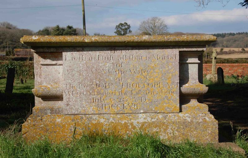
6/16 Trollope Tomb
Approximately 3 metres
to North-West of Church
of St. Mary
GV II
Chest tomb. 1757. Ashlar. Moulded base and top, and shaped corner balusters.
Inscribed: Here lieth in dust all that is mortal of Anne, the wife of the Revd.
John Trollope.
Listing NGR: SU5527570876
External links are from the relevant listing authority and, where applicable, Wikidata. Wikidata IDs may be related buildings as well as this specific building. If you want to add or update a link, you will need to do so by editing the Wikidata entry.


Other nearby listed buildings