Latitude: 51.7842 / 51°47'3"N
Longitude: -1.4769 / 1°28'37"W
OS Eastings: 436177
OS Northings: 209633
OS Grid: SP361096
Mapcode National: GBR 6VS.5DL
Mapcode Global: VHC02.CF12
Plus Code: 9C3WQGMF+M6
Entry Name: Dairy and Attached Wall Approximately 2 Metres North North West of Manor Farmhouse
Listing Date: 3 March 1988
Grade: II
Source: Historic England
Source ID: 1289586
English Heritage Legacy ID: 252641
ID on this website: 101289586
Location: Cogges, West Oxfordshire, OX28
County: Oxfordshire
District: West Oxfordshire
Civil Parish: Witney
Built-Up Area: Witney
Traditional County: Oxfordshire
Lieutenancy Area (Ceremonial County): Oxfordshire
Church of England Parish: Cogges
Church of England Diocese: Oxford
Tagged with: Agricultural structure
WITNEY COGGES
SP3609
Dairy and attached wall
8/87
approx. 2m. NNW of Manor
Farmhouse
II
GV
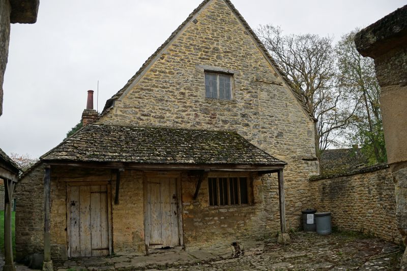
Dairy, now part of Cogges Farm Museum. C13 walls; remodelled in C17; shortened
in late C19. Uncoursed limestone rubble; gabled stone slate roof. One-unit plan.
2 storeys; gabled front. Timber lintel over C17 plank door set in ovolo-moulded
frame: "DAIRY" painted on wood above door c.1800. Timber lintel over C17
four-light chamfered wood-mullioned window to right. Pentice roof above; timber
lintel over loft opening. C17 plank door set in heavy pegged frame to left leads
to outshut, partly rebuilt in mid Cl9 brick. Left side wall also has 3-light
wood-mullioned window; right side wall has C17 three-light ovolo-moulded
wood-mullioned window and 2-light chamfered wood-mullioned window. Interior:
stop-chamfered beams. Three raised cracks with collar-purlin. Subsidiary
features: yard in front enclosed by rounded limestone rubble wall with ashlar
coping approximately 6 metres long. Originally a building attached to the C13
Manor House (q.v.), used as a dairy from at least the late C18.
Listing NGR: SP3618109633
External links are from the relevant listing authority and, where applicable, Wikidata. Wikidata IDs may be related buildings as well as this specific building. If you want to add or update a link, you will need to do so by editing the Wikidata entry.


Other nearby listed buildings