Approximate Location Map
Large Map »
Latitude: 53.7431 / 53°44'34"N
Longitude: -0.3365 / 0°20'11"W
OS Eastings: 509809
OS Northings: 428692
OS Grid: TA098286
Mapcode National: GBR GNP.KM
Mapcode Global: WHGFR.S5YV
Plus Code: 9C5XPMV7+6C
Entry Name: 20 Whitefriargate
Listing Date: 16 June 1971
Last Amended: 30 June 2022
Grade: II
Source: Historic England
Source ID: 1291327
English Heritage Legacy ID: 387841
ID on this website: 101291327
Location: Lisle Court, Kingston upon Hull, East Riding of Yorkshire, HU1
County: City of Kingston upon Hull
Electoral Ward/Division: Myton
Parish: Non Civil Parish
Built-Up Area: Kingston upon Hull
Traditional County: Yorkshire
Lieutenancy Area (Ceremonial County): East Riding of Yorkshire
Church of England Parish: Hull Most Holy and Undivided Trinity
Church of England Diocese: York
Tagged with: Building
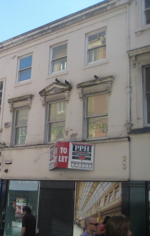
Mid- to late-C18 house, now (2022) a shop, with mid- to late-C19 alterations.
Mid- to late-C18 house, now a shop, with mid- to late-C19 alterations. Classical style.
MATERIALS: brick with a stucco front, and a slate roof.
PLAN: polygonal on plan, formerly part of a block of five houses and shops with numbers 16 to 19 Whitefriargate.
EXTERIOR: the narrow three-storey principal (north) elevation has a symmetrical three-bay street frontage onto Whitefriargate with a late-C20 shopfront to the ground floor with a recessed central entrance and fascia sign. On the first floor are three-horned plate-glass sashes, all of which rest on scrolled brackets; the central window has a moulded pediment and the outer windows have moulded cornices. To the second floor are three plate-glass sashes with slightly projecting sills. To the top of the elevation is a moulded eaves cornice. The pitched roof has a rendered west end ridge stack.
20 Whitefriargate was constructed in the mid- to late C18 as part of a single 15-bay build comprising five houses (numbers 16-20) on land forming part of the former Carmelite Estate owned by Hull Trinity House, a religious guild established in 1369 that became a mariners’ guild in the mid-C15 and has owned the Carmelite Estate since 1621. Hull Trinity House began developing major construction schemes for blocks of houses on the south side of Whitefriargate in the C18 and John Greenwood's 1835 book 'Picture of Hull' contains an engraving of the street looking from the north-east that shows this building as three-storey brick residences.
The buildings were in use as both shops and houses by the early C19. In the mid- to late C19, the building was re-fenestrated and rendered and the front elevation (depicted in an 1880s drawing by Frederick Schultz Smith) was designed with an alternating Palladian arrangement of triple bays in two window styles across the first floor: one triple bay with pediment and cornices to first-floor windows and another triple bay with plain window surrounds, and second-floor windows with plain window surrounds. The windows of 16-19 Whitefriargate were later altered and no longer match number 20.
20 Whitefriargate underwent some alteration in the late C20 to the ground-floor shopfront and to the rear, with alterations also to the ground floor.
20 Whitefriargate is listed at Grade II for the following principal reasons:
Architectural interest:
* for its attractive Palladian appearance on one of the principal shopping streets in Hull, designed to present a uniform appearance for the Hull Trinity House Estate.
Historic interest:
* as one of the key buildings on the south side of Whitefriargate where the majority of the buildings were constructed in the late C18 and early C19 to provide Trinity House with a rental income in addition to their shipping revenues.
Group value:
* the building is one of a range of listed buildings on Whitefriargate, including the former Neptune Inn, which together combine to impart the historical character of this part of Hull Old Town.
External links are from the relevant listing authority and, where applicable, Wikidata. Wikidata IDs may be related buildings as well as this specific building. If you want to add or update a link, you will need to do so by editing the Wikidata entry.


Other nearby listed buildings
