Approximate Location Map
Large Map »
Latitude: 51.7498 / 51°44'59"N
Longitude: -0.3408 / 0°20'26"W
OS Eastings: 514633
OS Northings: 206984
OS Grid: TL146069
Mapcode National: GBR H89.BN1
Mapcode Global: VHGPQ.18PX
Plus Code: 9C3XPMX5+WM
Entry Name: The Old Rectory
Listing Date: 8 May 1950
Last Amended: 27 August 1971
Grade: II
Source: Historic England
Source ID: 1295703
English Heritage Legacy ID: 163462
ID on this website: 101295703
Location: St Albans, St. Albans, Hertfordshire, AL1
County: Hertfordshire
District: St. Albans
Electoral Ward/Division: Verulam
Parish: Non Civil Parish
Built-Up Area: St Albans
Traditional County: Hertfordshire
Lieutenancy Area (Ceremonial County): Hertfordshire
Church of England Parish: Abbey Parish of St Albans
Church of England Diocese: St.Albans
Tagged with: Clergy house
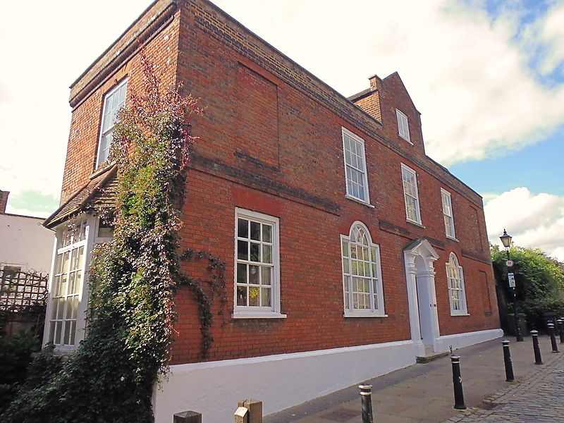
SUMPTER YARD
1.
1582 The Old Rectory
TL 1406 NE 14/98 8.5.50.
II
2.
Late C18, brick house of 2 storeys and attic, 5 windows, Hipped, tiled,
mansard roof with one central brick gabled dormer rising from parapet.
Low, brick parapet over broad string; another string at 1st floor level.
Left and right 1st floor windows and right ground floor windows blocked.
Other windows are sashes with glazing bars in near-flush box frames under
gauged, flat, brick arches, except for 2 inner ground floor Venetian windows
with interlacing glazing bars in round heads.
Central door of 4 fielded and 2 flat panels with cornice head and radial
fanlight in doorcase of order with open pediment over. NMR.
Listing NGR: TL1463306984
External links are from the relevant listing authority and, where applicable, Wikidata. Wikidata IDs may be related buildings as well as this specific building. If you want to add or update a link, you will need to do so by editing the Wikidata entry.


Other nearby listed buildings
