Latitude: 51.2085 / 51°12'30"N
Longitude: -3.5953 / 3°35'43"W
OS Eastings: 288657
OS Northings: 146682
OS Grid: SS886466
Mapcode National: GBR LC.430R
Mapcode Global: VH5JW.MWPG
Plus Code: 9C3R6C53+9V
Entry Name: Chantry Cottage
Listing Date: 22 May 1969
Last Amended: 2 January 1986
Grade: II
Source: Historic England
Source ID: 1296184
English Heritage Legacy ID: 265464
ID on this website: 101296184
Location: Porlock, Somerset, TA24
County: Somerset
District: Somerset West and Taunton
Civil Parish: Porlock
Built-Up Area: Porlock
Traditional County: Somerset
Lieutenancy Area (Ceremonial County): Somerset
Tagged with: Cottage
SS8846 PORLOCK CP THE DRANG (East side)
Chantry Cottage
24/51 (formerly listed as 2 separate
items Nos 1 and 2 High Street)
22.5.69
GV II
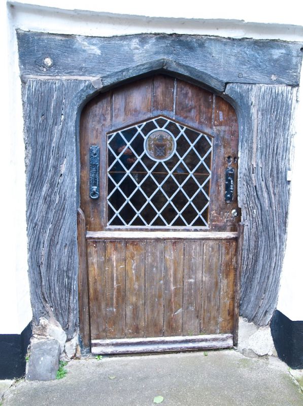
Chantry priest's dwelling, now cottage. Late C15, subsequently much altered. Rendered over rubble, double Roman tiled
roof, stone stack right gable end, inserted rendered first floor external stack left gable end. Plan: 2 cell and cross
passage with additions at rear. Two storeys, 2 bays; leaded C20 2-light casements, central chamfered 4-centred arch
door frame, somewhat eroded with C20 stable-type door. Left return first floor stone lancet presumably to stair,
cinquefoil headed single light window left, pantiled crosswing addition with outshot visible on right return. Interior
not seen. This is believed to have been the dwelling of the priests attached to the Harington Chantry in St Dubricius
Church (qv) Porlock, which was licenced in 1474. (Photograph in NMR).
SS8846 PORLOCK CP HIGH STREET (South side)
24/51 Nos 1 and 2
(Chantry Cottage)
22.5.69
GV II
For Chantry Cottage, see The Drang (East side), Porlock.
Listing NGR: SS8865746682
External links are from the relevant listing authority and, where applicable, Wikidata. Wikidata IDs may be related buildings as well as this specific building. If you want to add or update a link, you will need to do so by editing the Wikidata entry.


Other nearby listed buildings