Approximate Location Map
Large Map »
Latitude: 52.3298 / 52°19'47"N
Longitude: -2.018 / 2°1'4"W
OS Eastings: 398866
OS Northings: 270188
OS Grid: SO988701
Mapcode National: GBR 2G0.SQP
Mapcode Global: VH9ZL.ZP0V
Plus Code: 9C4V8XHJ+WQ
Entry Name: Tutnall Hall
Listing Date: 23 April 1952
Last Amended: 16 July 1986
Grade: II
Source: Historic England
Source ID: 1296604
English Heritage Legacy ID: 156234
ID on this website: 101296604
Location: Tutnall, Bromsgrove, Worcestershire, B60
County: Worcestershire
District: Bromsgrove
Civil Parish: Tutnall and Cobley
Traditional County: Worcestershire
Lieutenancy Area (Ceremonial County): Worcestershire
Church of England Parish: Tardebigge
Church of England Diocese: Worcester
Tagged with: House
SO 97 SE TUTNALL & COBLEY CP TUTNALL
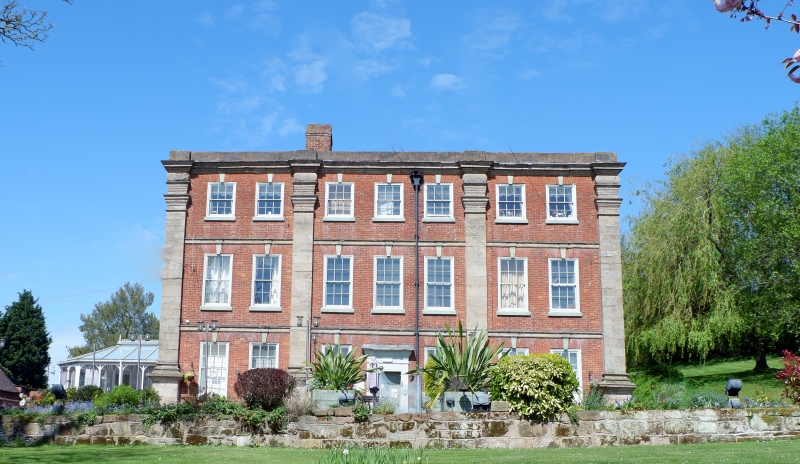
5/182 Tutnall Hall (Formerly listed
as Tutnall Hall Farmhouse)
23.4152
- II
Country house. Early C18, partly rebuilt early C19 with some mid-C20
alterations. Brick with stone dressings and hipped slate roofs. Three
storeys, moulded stone cornice, three bays divided by giant Doric pilasters;
stone bands to ground and first floor; 2 + 3 + 2 windows: boxed glazing bar
sashes under rubbed brick heads with stone keystones linked to bands; second
floor: sashes of lower height; ground floor: central entrance has a pilastered
wooden doorcase with moulded cornice and door of four flush panels. Interior:
early C19 staircase with ramped hand rail, stick balusters and turned newells.
(BoE, p 277; Peter Reid, Burke's and Savill's Guide to Country Houses Volume II,
Herefordshire, Shropshire, Warwickshire, Worcestershire, 1980, p 229).
Listing NGR: SO9886670187
External links are from the relevant listing authority and, where applicable, Wikidata. Wikidata IDs may be related buildings as well as this specific building. If you want to add or update a link, you will need to do so by editing the Wikidata entry.


Other nearby listed buildings
