Approximate Location Map
Large Map »
Latitude: 53.8264 / 53°49'34"N
Longitude: -1.2791 / 1°16'44"W
OS Eastings: 447547
OS Northings: 436920
OS Grid: SE475369
Mapcode National: GBR MSH6.W2
Mapcode Global: WHDBN.B24Y
Plus Code: 9C5WRPGC+H8
Entry Name: White Rose Farm
Listing Date: 16 May 1986
Grade: II
Source: Historic England
Source ID: 1296614
English Heritage Legacy ID: 326363
ID on this website: 101296614
Location: Saxton, North Yorkshire, LS24
County: North Yorkshire
District: Selby
Civil Parish: Saxton with Scarthingwell
Built-Up Area: Saxton
Traditional County: Yorkshire
Lieutenancy Area (Ceremonial County): North Yorkshire
Church of England Parish: Saxton All Saints
Church of England Diocese: York
Tagged with: Agricultural structure
SAXTON WITH SCARTHINGWELL DAM LANE
SE 43 NE
(north side)
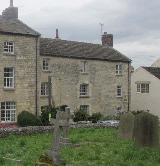
3/25 White Rose Farm
GV II
House. Late C18 - early C19 with later additions and alterations.
Magnesian limestone ashlar with cast-tile roof. 3 storeys, 3 first-floor
windows. Off-centre entrance a part-glazed door. Multi-paned casement
windows throughout under cambered heads. End stacks.
Listing NGR: SE4754836918
External links are from the relevant listing authority and, where applicable, Wikidata. Wikidata IDs may be related buildings as well as this specific building. If you want to add or update a link, you will need to do so by editing the Wikidata entry.


Other nearby listed buildings
