Approximate Location Map
Large Map »
Latitude: 53.9334 / 53°56'0"N
Longitude: -2.1423 / 2°8'32"W
OS Eastings: 390757
OS Northings: 448590
OS Grid: SD907485
Mapcode National: GBR FQHY.0R
Mapcode Global: WHB7D.2D4G
Plus Code: 9C5VWVM5+83
Entry Name: Bells Farmhouse
Listing Date: 31 October 1988
Grade: II
Source: Historic England
Source ID: 1296771
English Heritage Legacy ID: 324523
ID on this website: 101296771
Location: Thornton-in-Craven, North Yorkshire, BD23
County: North Yorkshire
District: Craven
Civil Parish: Thornton in Craven
Built-Up Area: Thornton-in-Craven
Traditional County: Yorkshire
Lieutenancy Area (Ceremonial County): North Yorkshire
Tagged with: Farmhouse
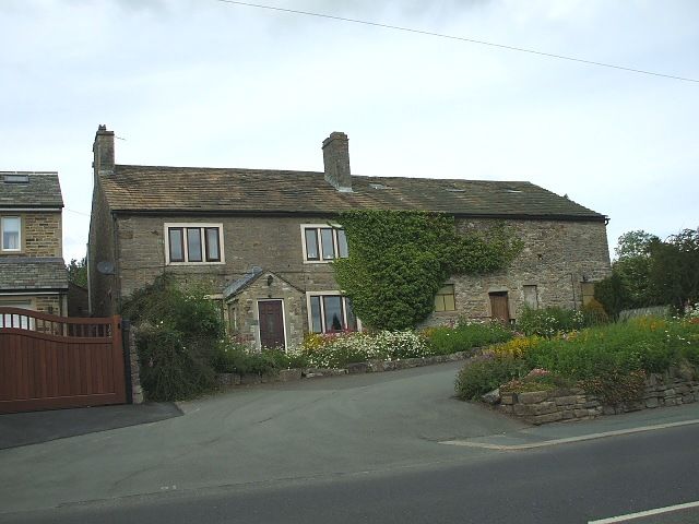
SD 9748 THORNTON-IN-CRAVEN MAIN STREET
(North side)
9/144 BellsFarmhouse
GV II
Farmhouse, C18. Squared rubble, stone slate roof. 2 storeys. Recent porch, with
one 3-light recessed square mullion window to each side on each floor. Gable chimneys.
Listing NGR: SD9075748590
External links are from the relevant listing authority and, where applicable, Wikidata. Wikidata IDs may be related buildings as well as this specific building. If you want to add or update a link, you will need to do so by editing the Wikidata entry.


Other nearby listed buildings
