Approximate Location Map
Large Map »
Latitude: 50.0839 / 50°5'2"N
Longitude: -5.3173 / 5°19'2"W
OS Eastings: 162785
OS Northings: 25694
OS Grid: SW627256
Mapcode National: GBR FX7G.K4D
Mapcode Global: VH138.S5B0
Plus Code: 9C2P3MMM+H3
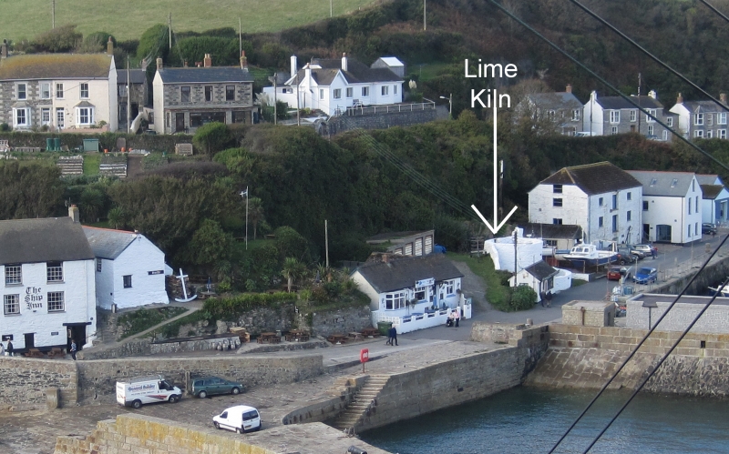
Entry Name: Lime Kiln
Listing Date: 9 February 1994
Grade: II
Source: Historic England
Source ID: 1297623
English Heritage Legacy ID: 385571
ID on this website: 101297623
Location: Porthleven, Cornwall, TR13
County: Cornwall
Civil Parish: Porthleven
Built-Up Area: Porthleven
Traditional County: Cornwall
Lieutenancy Area (Ceremonial County): Cornwall
Church of England Parish: Breage with Godolphin and Ashton
Church of England Diocese: Truro
Tagged with: Lime kiln
HELSTON
SW6225 THE WHARF, Porthleven
631-1/6/266 (West side)
Lime kiln
GV II
Lime kiln. 1816. For Archibald Blair. Lime-washed rubble.
Semicircular-on-plan built against a retaining wall of loading
platform. Small doorway into right-hand side.
Listing NGR: SW6278525694
External links are from the relevant listing authority and, where applicable, Wikidata. Wikidata IDs may be related buildings as well as this specific building. If you want to add or update a link, you will need to do so by editing the Wikidata entry.


Other nearby listed buildings
