Latitude: 53.0764 / 53°4'34"N
Longitude: -0.8124 / 0°48'44"W
OS Eastings: 479658
OS Northings: 353897
OS Grid: SK796538
Mapcode National: GBR CLM.5DT
Mapcode Global: WHFHH.HXCY
Plus Code: 9C5X35GQ+G2
Entry Name: 49-50 Stodman Street
Listing Date: 19 May 1971
Last Amended: 18 June 2024
Grade: II
Source: Historic England
Source ID: 1297654
English Heritage Legacy ID: 385202
ID on this website: 101297654
Location: Newark-on-Trent, Newark and Sherwood, Nottinghamshire, NG24
County: Nottinghamshire
District: Newark and Sherwood
Civil Parish: Newark
Built-Up Area: Newark-on-Trent
Traditional County: Nottinghamshire
Lieutenancy Area (Ceremonial County): Nottinghamshire
Church of England Parish: Newark-upon-Trent with Coddington
Church of England Diocese: Southwell and Nottingham
Tagged with: Building
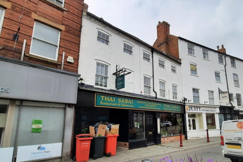
Two dwellings constructed in the C18, with ground floor converted into two retail units in C20.
Two dwellings constructed in the C18, with ground floor converted into two retail units in C20.
MATERIALS: constructed of brick with timber shopfronts under a clay pantile roof with two gable stacks.
PLAN: rectangular on plan the principal facade faces north east.
EXTERIOR: the building has three storeys and is over five bays with two late-C19 timber shopfronts at ground floor which sit under a continuous C20 fascia. Appearing centrally (sitting east of number 50) is a six-panel C20 door. To the left of this a recessed, glazed doorway flanked by single pane windows on plain stallrisers. To the west there is single plate glass on brick stallrisers. The first floor windows are six-over-six sashes, except the second from east which is blank. The second floor windows are three-over-three sashes all under segmental heads. Above is a dentilled cornice beneath the eaves and pantile roof.
Newark appears as Newerche in the 1086 Domesday Book. It’s original name Niweweorche (meaning 'New work') is likely associated with the meaning "New fort". The site of Newark Castle was founded by Robert Bloet, Bishop of Lincoln in 1073 and rebuilt in stone from 1123 and 1133. A bridge over the Trent was built under charter from Henry I at a similar time. In the C15 and C16, Newark became a prosperous market town centred on the wool and cloth trade and characterised by a dense street pattern surrounding the market square. It was incorporated by the Crown in 1549. Significant development occurred during the C18 in response to growing trade along the Great North Road, with a number of handsome terraced Georgian buildings evident from this time. In 1775 a new bridge over the River Trent was constructed, it was further improved in 1848 and forms the current ‘Trent Bridge’. The Market Place was rebuilt in the C18 with coaching inns, the houses of leading citizens and the splendid new Town Hall (1773) by John Carr. By 1801 Newark had a population of 6,730 and was Nottinghamshire’s second town.
49 and 50 Stodman Street would originally have been built as two houses in the late C18, with alterations made during the C19 and C20. The overall form of the building appears to have changed little since construction, with the only substantive alterations including a reconfigured ground-floor façade as part of the conversion into two shops.
External links are from the relevant listing authority and, where applicable, Wikidata. Wikidata IDs may be related buildings as well as this specific building. If you want to add or update a link, you will need to do so by editing the Wikidata entry.


Other nearby listed buildings