Latitude: 51.5321 / 51°31'55"N
Longitude: -0.108 / 0°6'28"W
OS Eastings: 531331
OS Northings: 183162
OS Grid: TQ313831
Mapcode National: GBR M4.XY
Mapcode Global: VHGQT.2RRC
Plus Code: 9C3XGVJR+RR
Entry Name: 34-40, Pentonville Road
Listing Date: 29 September 1972
Grade: II
Source: Historic England
Source ID: 1297991
English Heritage Legacy ID: 369197
ID on this website: 101297991
Location: Pentonville, Islington, London, N1
County: London
District: Islington
Electoral Ward/Division: Barnsbury
Parish: Non Civil Parish
Built-Up Area: Islington
Traditional County: Middlesex
Lieutenancy Area (Ceremonial County): Greater London
Church of England Parish: St Silas Pentonville
Church of England Diocese: London
Tagged with: Building
ISLINGTON
TQ3183SW PENTONVILLE ROAD 635-1/64/680 (North side) 29/09/72 Nos.34-40 (Even)
GV II
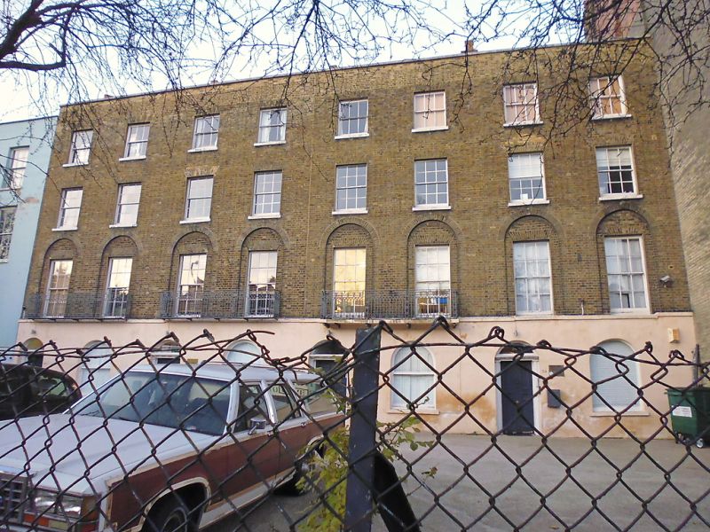
Four terraced houses, now in commercial use. Set back from Pentonville Road. c.1820-1830, altered C20. Yellow stock brick set in Flemish bond with stucco ground-floor lined as ashlar; roofs obscured by parapet, brick party-wall stacks. Formerly side-hall entrance plan, now connected commercial showrooms and offices. Four storeys; 2 windows each. Round-arched ground-floor openings: doorways altered, nos. 34 and 36 survive with fluted 1/2 column jambs carrying modillioned corniced-heads, plain fanlights and 6-panelled doors. Altered 1/1 and single plate-glass sashes; stucco sill band to 1st floor full-length 6/6 sashes with coupled and bracketed cast-iron balconies (no. 34 removed c.1980) with Gothic-style railings. Upper floors with gauged-brick flat arches, 1st floor sashes set in arched recesses. 6/6 2nd floors sashes; 3/3 3rd floor sashes. Plain parapets with coping stone.
Listing NGR: TQ3133183162
External links are from the relevant listing authority and, where applicable, Wikidata. Wikidata IDs may be related buildings as well as this specific building. If you want to add or update a link, you will need to do so by editing the Wikidata entry.


Other nearby listed buildings