Approximate Location Map
Large Map »
Latitude: 51.7147 / 51°42'53"N
Longitude: -1.9645 / 1°57'52"W
OS Eastings: 402550
OS Northings: 201779
OS Grid: SP025017
Mapcode National: GBR 3QY.G4Q
Mapcode Global: VHB2Q.W5T9
Plus Code: 9C3WP27P+V6
Entry Name: 28-34 Tower Street and attached walls
Listing Date: 24 May 1993
Grade: II
Source: Historic England
Source ID: 1298661
English Heritage Legacy ID: 365458
ID on this website: 101298661
Location: Cirencester, Cotswold, Gloucestershire, GL7
County: Gloucestershire
District: Cotswold
Civil Parish: Cirencester
Built-Up Area: Cirencester
Traditional County: Gloucestershire
Lieutenancy Area (Ceremonial County): Gloucestershire
Church of England Parish: Cirencester St John the Baptist
Church of England Diocese: Gloucester
Tagged with: Wall
SP0201
578-1/6/320
CIRENCESTER
TOWER STREET (east side)
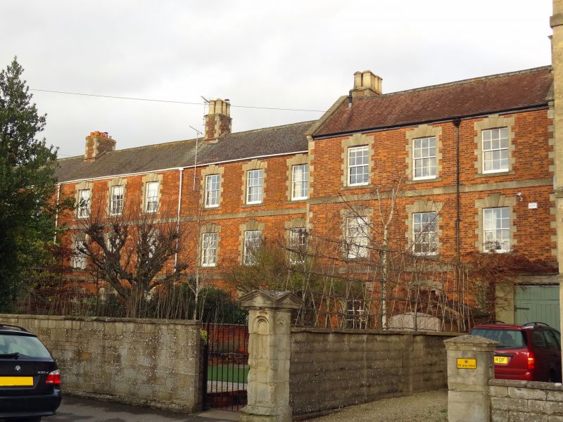
Nos.28-34 (even) and attached walls
GV
II
Formerly known as: Nos. 28-34 Bromley Terrace TOWER STREET.
Four houses. c1860-1870, and late C19. Red brick with limestone ashlar dressings to front, coursed squared limestone to sides, coursed squared limestone rubble and brick to rear; roofs have blue fish scale clay tiles to left (Nos. 30-34), similar red tiles to right (No. 28), rear slopes have plain clay tiles except No. 30, tiled as front. Five ridge and left- and right-end stacks in brick with ashlar dressings largely retain C19 clay pots with moulded tops and faceted corners.
Terrace of three houses to left (Nos. 30-34) with attached late C19 house in matching style breaking forward to right (No. 28). Three storey twelve-window range. First floor has twelve 6/6-pane sashes in ashlar surrounds with keyed lintels and stone cills; second floor has twelve similar windows. Ground floor has eight similar windows and four doors each of six flush panels with single-pane overlights in similar surrounds. Ashlar plinth, band courses over first and second floors, flush quoins to left and right angles.
Attached brick walls with ashlar copings approximately 2 metres high, to far right (No. 28) rebuilt in reconstituted stone, terminated by ashlar piers approximately 2 metres high with recessed round-headed panels to sides and pedimented caps.
INTERIORS; not inspected.
(1st edition 25" OS surveyed 1875).
Listing NGR: SP0255001779
External links are from the relevant listing authority and, where applicable, Wikidata. Wikidata IDs may be related buildings as well as this specific building. If you want to add or update a link, you will need to do so by editing the Wikidata entry.


Other nearby listed buildings
