Approximate Location Map
Large Map »
Latitude: 53.354 / 53°21'14"N
Longitude: -2.9933 / 2°59'35"W
OS Eastings: 333980
OS Northings: 384585
OS Grid: SJ339845
Mapcode National: GBR 7YJN.RD
Mapcode Global: WH87D.ZYSM
Plus Code: 9C5V9234+JM
Entry Name: 61-67, Corniche Road
Listing Date: 20 December 1965
Grade: II
Source: Historic England
Source ID: 1300346
English Heritage Legacy ID: 215400
ID on this website: 101300346
Location: Port Sunlight, Wirral, Merseyside, CH62
County: Wirral
Electoral Ward/Division: Bromborough
Parish: Non Civil Parish
Built-Up Area: Bebington
Traditional County: Cheshire
Lieutenancy Area (Ceremonial County): Merseyside
Church of England Parish: New Ferry St Mark
Church of England Diocese: Chester
Tagged with: Building
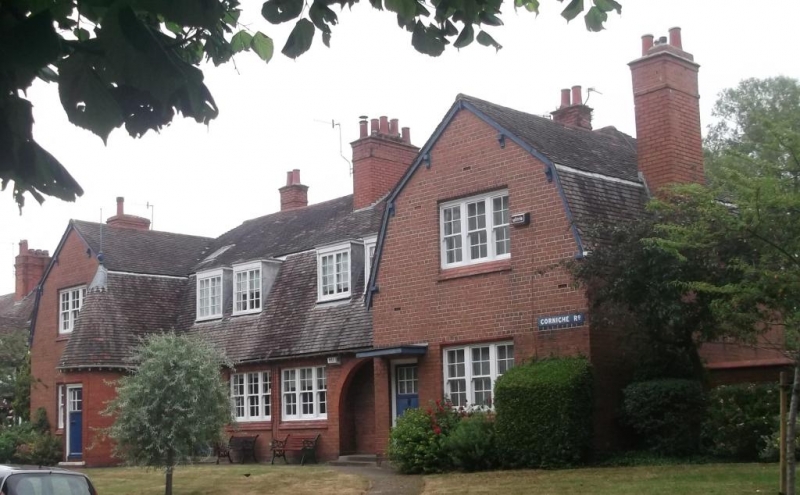
SJ 3384 NE
13/80
BEBINGTON, Port Sunlight,
CORNICHE ROAD (east side),
Nos. 61 to 67 (odd)
20.12.65
G.V. II
4 houses. 1898. By Huon. A. Matear. Brick with tile gambrel
roof. One storey with attic, 4 bays; end bays under
gambrel gables, that to 1st bay has round-ended projection
under steep roof with spike finial. Windows have triple
sashes with glazing bars; central bays have paired flat-
topped dormers with 2-light small-paned casements.
Entrances have small-paned lights with leaded glazing, those
to central bays in round-headed recesses, that to end bay
with flat canopy. One cross-axial stack, 2 return lateral
stacks and 2 to rear. Rear similar, privies.
Listing NGR: SJ3398084585
External links are from the relevant listing authority and, where applicable, Wikidata. Wikidata IDs may be related buildings as well as this specific building. If you want to add or update a link, you will need to do so by editing the Wikidata entry.


Other nearby listed buildings
