Approximate Location Map
Large Map »
Latitude: 53.3541 / 53°21'14"N
Longitude: -2.9923 / 2°59'32"W
OS Eastings: 334049
OS Northings: 384594
OS Grid: SJ340845
Mapcode National: GBR 7YJN.ZC
Mapcode Global: WH87F.0YDK
Plus Code: 9C5V9235+J3
Entry Name: 71-75, Bolton Road
Listing Date: 20 December 1965
Grade: II
Source: Historic England
Source ID: 1343457
English Heritage Legacy ID: 215326
ID on this website: 101343457
Location: Port Sunlight, Wirral, Merseyside, CH62
County: Wirral
Electoral Ward/Division: Bromborough
Parish: Non Civil Parish
Built-Up Area: Bebington
Traditional County: Cheshire
Lieutenancy Area (Ceremonial County): Merseyside
Church of England Parish: New Ferry St Mark
Church of England Diocese: Chester
Tagged with: Building
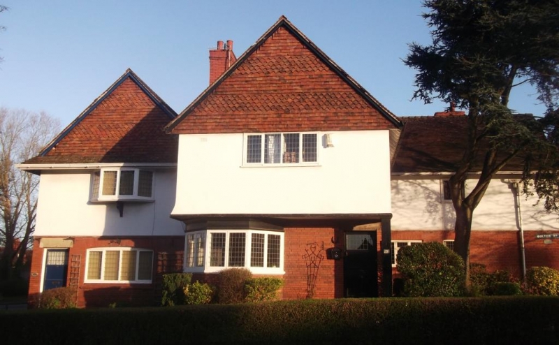
BEBINGTON BOLTON ROAD
SJ 38 SW
(north side)
Port Sunlight
6/17 Nos. 71, 73
20.12.65 and 75
G.V. II
3 houses. 1898. By Douglas and Minshull. Brick with plaster
1st floor, tile-hung gables with fishscale bands, and tile
roofs. 2 storeys, 3 bays; 1st 2 bays gabled, the 2nd projects
with jettied 1st floor; 3rd bay recessed by one bay. Windows
have leaded casements, those to ground floor with gauged-brick
cambered arches, that to 1st bay of 4 lights; 3rd bay has 2-
light window and inserted 3-light window. 2nd bay has 6-light
canted bay window, with 2-lights to left return. 1st floor
has 4-light canted oriel to 1st bay with tile canopy, swept
out from tile-hanging; 2nd bay window of 4 lights, 3rd bay 2-
light window. Entrances have stone lintels and 3-panel doors
with leaded lights. Valley stack and rear stack. Returns
similar, that to 3rd bay as 1st bay.
Listing NGR: SJ3404984594
External links are from the relevant listing authority and, where applicable, Wikidata. Wikidata IDs may be related buildings as well as this specific building. If you want to add or update a link, you will need to do so by editing the Wikidata entry.


Other nearby listed buildings
