Approximate Location Map
Large Map »
Latitude: 53.8462 / 53°50'46"N
Longitude: -1.8636 / 1°51'48"W
OS Eastings: 409074
OS Northings: 438898
OS Grid: SE090388
Mapcode National: GBR HRFY.BZ
Mapcode Global: WHC91.BLV8
Plus Code: 9C5WR4WP+FH
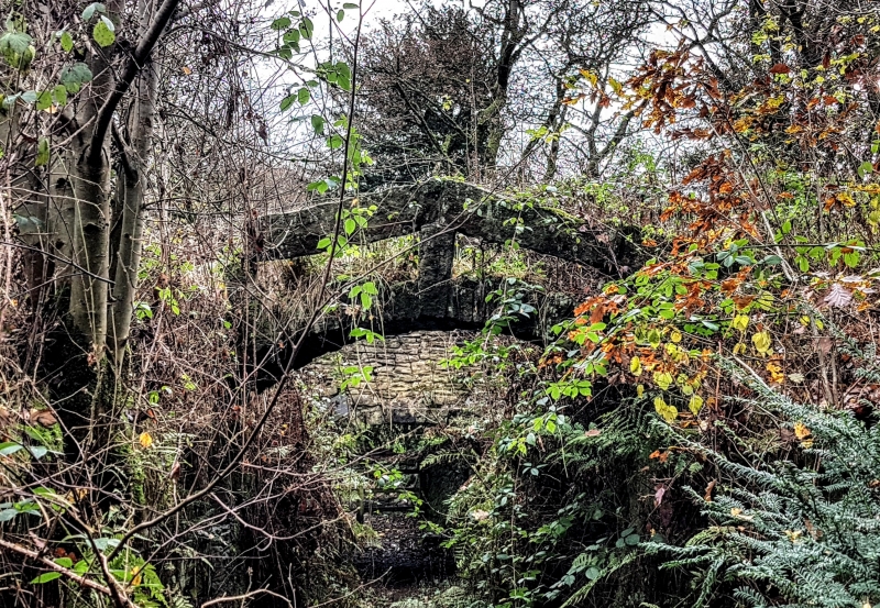
Entry Name: Footbridge Approximately 10 Metres East of Coppice Pond
Listing Date: 18 October 1985
Grade: II
Source: Historic England
Source ID: 1300586
English Heritage Legacy ID: 338052
ID on this website: 101300586
Location: Harden, Bradford, West Yorkshire, BD16
County: Bradford
Civil Parish: Harden
Traditional County: Yorkshire
Lieutenancy Area (Ceremonial County): West Yorkshire
Church of England Parish: Harden
Church of England Diocese: Leeds
Tagged with: Footbridge
BINGLEY ST. IVES ESTATE
SE03NE
SE090388
5/188 Footbridge approx.
10m east of
Coppice Pond
II
Footbridge. Probably late C18. Dressed rubble. Pack-horse-
type bridge. Single segmental arch with parapet formed of
monoliths supported by extended keystone and 2 voussoirs and
open beneath in the form of a stone handrail.
Listing NGR: SE0907438898
External links are from the relevant listing authority and, where applicable, Wikidata. Wikidata IDs may be related buildings as well as this specific building. If you want to add or update a link, you will need to do so by editing the Wikidata entry.


Other nearby listed buildings
